How Satellites Aid in Global Military Coordination
In today's fast-paced world, the role of satellites in military operations cannot be overstated. They have become the backbone of modern warfare, enabling armed forces to operate with unprecedented efficiency and precision. Imagine a vast chessboard where each piece represents a military unit, and satellites serve as the eyes and ears of the players, providing crucial information that can turn the tide of battle. From communication to surveillance, navigation, and data sharing, satellites are the unsung heroes of global military coordination.
One of the most significant contributions of satellites is their ability to facilitate enhanced communication. Military forces operate in diverse environments, often separated by great distances. Satellites provide secure and reliable communication channels that ensure real-time information exchange. This capability is vital for effective command and control during operations. Imagine a general on the battlefield, able to communicate instantly with troops thousands of miles away, adjusting strategies and issuing commands without delay. This level of connectivity is crucial for success in any military operation.
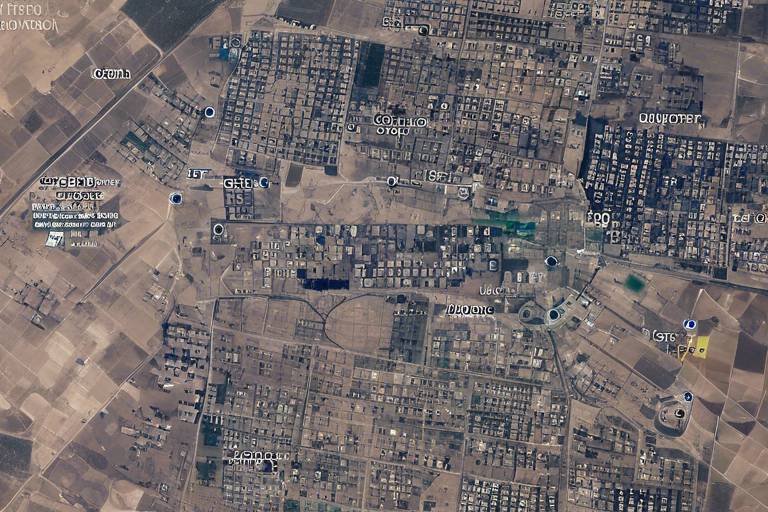
Moreover, the surveillance capabilities offered by military satellites are pivotal. They play a crucial role in reconnaissance and intelligence gathering, allowing forces to monitor enemy movements and assess battlefield conditions from space. This satellite-derived information enhances strategic planning and decision-making. For instance, Earth observation satellites capture high-resolution images of the terrain and infrastructure, enabling military analysts to evaluate potential threats. With advanced imaging techniques such as synthetic aperture radar and multispectral imaging, military forces can detect changes in the environment, providing critical insights for decision-makers.
In addition to imagery, the real-time data processing from satellite imagery allows for immediate analysis. This means that military units can adapt quickly to evolving situations on the battlefield, responding to threats as they arise. Furthermore, signals intelligence (SIGINT) satellites intercept and analyze electronic communications, offering valuable information about enemy activities and intentions. This intelligence is essential for preemptive action and strategic planning, ensuring that military forces are always one step ahead.
When it comes to navigation and positioning, Global Navigation Satellite Systems (GNSS) are indispensable. They allow military forces to coordinate movements and execute missions with pinpoint accuracy, even in hostile environments. The integration of GPS technology in military operations enhances targeting accuracy and troop movement, significantly reducing the risk of collateral damage. Imagine a pilot flying a mission, guided by GPS, who can strike a target with surgical precision, minimizing unintended consequences. However, despite these advancements, military navigation systems face challenges such as jamming and spoofing, which necessitate the development of countermeasures to ensure operational effectiveness.
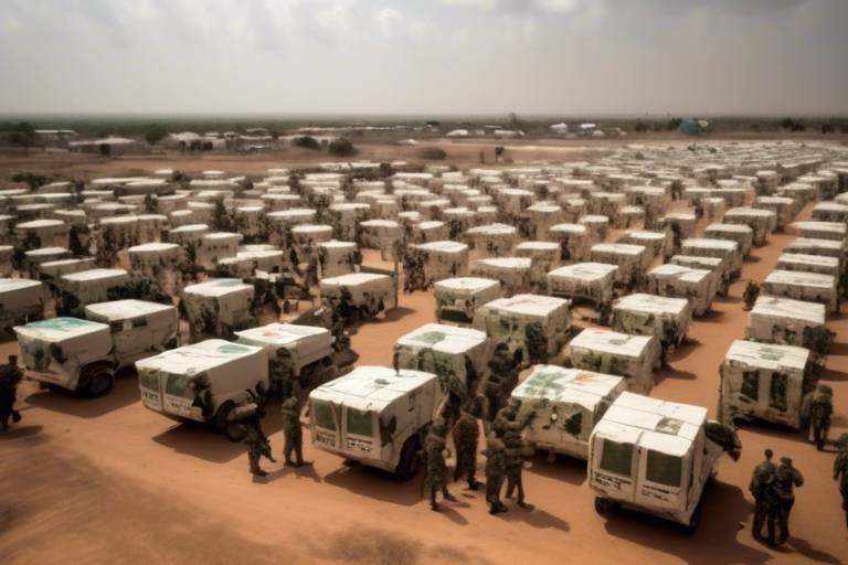
Satellites also play a crucial role in facilitating seamless data sharing among allied military forces. This collaboration is essential for responding to global threats and maintaining security. Joint military exercises, for instance, benefit greatly from satellite technology, enabling participating nations to coordinate actions effectively. This enhances interoperability and readiness for real-world scenarios. However, ensuring the security of shared satellite data is paramount. Breaches can compromise military operations, making robust encryption and cybersecurity measures essential components of satellite communications.
- What are military satellites used for? Military satellites are primarily used for communication, surveillance, navigation, and data sharing among armed forces.
- How do satellites enhance communication in military operations? Satellites provide secure and reliable channels for real-time information exchange, critical for effective command and control.
- What is the role of Earth observation satellites? They capture high-resolution images of the terrain, enabling military analysts to assess threats and optimize strategies.
- What challenges do military navigation systems face? Challenges include jamming and spoofing, which require the development of countermeasures to maintain effectiveness.
- Why is data sharing important among allied forces? It promotes collaboration and enhances readiness for joint operations in response to global threats.
Enhanced Communication
In the fast-paced world of military operations, communication is the lifeblood that keeps everything running smoothly. Imagine trying to conduct a complex operation without a reliable way to share information—it's like trying to navigate a ship through fog without a compass! Fortunately, satellites have revolutionized military communication, providing secure and reliable channels that span the globe. This capability is not just a luxury; it’s a necessity for effective command and control during operations.
Military forces rely on satellite communication systems to ensure real-time information exchange across vast distances. Whether it’s coordinating troop movements, sharing intelligence, or issuing commands, these satellites play a pivotal role in maintaining situational awareness. The importance of this cannot be overstated. In high-stakes scenarios, even a momentary lapse in communication can lead to disastrous outcomes. For instance, during joint operations, the ability to communicate instantly with allied forces can make the difference between success and failure.
Moreover, satellite communication systems are designed to operate in challenging environments where traditional communication methods might falter. They are less susceptible to interference from natural obstacles or enemy actions, making them indispensable in conflict zones. This resilience is achieved through advanced technologies that ensure signals can be transmitted securely and efficiently, even in the most adverse conditions.
To illustrate the impact of satellite communication on military effectiveness, consider the following key benefits:
- Real-Time Updates: Commanders can receive immediate updates about battlefield conditions, allowing for quick decision-making.
- Secure Channels: Encryption and advanced security measures protect sensitive information from interception.
- Global Reach: Communication is possible anywhere on the planet, ensuring that no unit is left out of the loop.
In conclusion, enhanced communication through satellite technology is a game-changer for military operations. It enables forces to maintain a cohesive strategy, adapt to changing situations, and ultimately achieve their objectives with greater efficiency. As military operations continue to evolve, the reliance on satellite communication will only grow, underscoring its vital role in modern warfare.
Surveillance Capabilities
When it comes to modern warfare, the ability to see what your enemy is doing can be the difference between victory and defeat. Military satellites are pivotal in reconnaissance and intelligence gathering, enabling forces to monitor enemy movements and assess battlefield conditions from space. Imagine having a bird's-eye view of the entire battlefield, where every movement is tracked and analyzed in real-time. This capability enhances strategic planning and allows military leaders to make informed decisions quickly.
One of the key types of satellites used for surveillance is the Earth Observation Satellite. These high-tech devices capture high-resolution images of the terrain and infrastructure below. With the help of advanced imaging techniques, military analysts can evaluate potential threats and optimize operational strategies based on current conditions. For instance, if a military unit is planning an operation in a mountainous region, satellite imagery can provide crucial information about the terrain, helping to identify the safest and most effective routes for troop movement.
Advanced imaging techniques play a critical role in enhancing the capabilities of military satellites. Techniques such as synthetic aperture radar (SAR) and multispectral imaging are at the forefront of this technology. SAR can penetrate clouds and darkness, providing continuous surveillance regardless of weather conditions or time of day. On the other hand, multispectral imaging captures data across various wavelengths, allowing analysts to detect changes in the environment, such as the movement of vehicles or the construction of enemy fortifications.
Real-time data processing from satellite imagery allows for immediate analysis, enabling military units to adapt quickly to evolving situations on the battlefield. This capability is crucial; in fast-paced military operations, the ability to respond to new information can lead to a decisive advantage. For example, if satellite imagery reveals an unexpected troop buildup by the enemy, commanders can adjust their strategies on the fly, potentially thwarting an impending attack.
Another critical aspect of military surveillance is signals intelligence (SIGINT). SIGINT satellites intercept and analyze electronic communications, providing valuable information on enemy activities and intentions. This form of intelligence is essential for preemptive action and strategic planning. By understanding what the enemy is saying and doing, military forces can anticipate moves and counteract them effectively.
In summary, the surveillance capabilities provided by military satellites are not just a technological marvel; they are a game-changer in the realm of global military operations. With the ability to gather and analyze vast amounts of data from space, military forces can maintain a strategic edge over their adversaries. As technology continues to evolve, the role of satellites in military surveillance will only become more critical, ensuring that armed forces are always one step ahead.
- What are military satellites used for? Military satellites are primarily used for communication, surveillance, navigation, and data sharing among armed forces.
- How do Earth Observation Satellites work? These satellites capture high-resolution images of the Earth, allowing military analysts to monitor enemy movements and assess battlefield conditions.
- What is signals intelligence (SIGINT)? SIGINT involves intercepting and analyzing electronic communications to gather information about enemy activities and intentions.
- How does real-time data processing benefit military operations? It allows military units to quickly adapt to changing situations on the battlefield, providing a decisive advantage in combat scenarios.
Earth Observation Satellites
Earth observation satellites play an indispensable role in modern military operations. These sophisticated devices orbit the Earth, capturing high-resolution images and data that provide invaluable insights into various terrains and infrastructures. Imagine having a bird's-eye view of a battlefield from space; this is precisely what these satellites offer. They allow military analysts to evaluate potential threats and optimize operational strategies based on real-time conditions. For instance, if a satellite detects unusual troop movements or infrastructure changes, military leaders can adjust their tactics promptly, ensuring they are always one step ahead of the adversary.
One of the most significant advantages of earth observation satellites is their ability to provide persistent surveillance. Unlike traditional reconnaissance methods, which can be limited by weather or time constraints, satellites can monitor an area continuously, day or night. This persistent capability is crucial for maintaining situational awareness, especially in conflict zones where conditions can change rapidly. The data gathered can be analyzed to identify patterns of behavior, assess enemy capabilities, and even predict future actions. In essence, these satellites transform vast amounts of data into actionable intelligence.
To understand how these satellites work, it's important to highlight some of the advanced imaging techniques they employ. Techniques such as synthetic aperture radar (SAR) and multispectral imaging are at the forefront of military reconnaissance. SAR can penetrate cloud cover and darkness, providing detailed images regardless of weather conditions, while multispectral imaging captures data across various wavelengths, allowing analysts to distinguish between different materials and detect camouflaged objects. This multifaceted approach to imaging equips military forces with a comprehensive understanding of the battlefield.
Moreover, the integration of real-time data processing capabilities into these satellites has revolutionized military operations. With the ability to analyze images and data as they are received, military units can react swiftly to evolving situations. This capability is akin to having a live feed from the battlefield, enabling commanders to make informed decisions on the fly. For instance, if a satellite detects an enemy buildup in a specific area, ground forces can be repositioned immediately to counter the threat, significantly improving operational effectiveness.
In conclusion, earth observation satellites are not just tools; they are essential components of modern military strategy. By providing real-time information and advanced analytical capabilities, they empower military forces to make informed decisions, adapt to changing environments, and ultimately enhance their operational readiness. The future of military operations will undoubtedly continue to rely heavily on these technological marvels, ensuring that armed forces remain agile and prepared for any challenge that may arise.
- What are Earth observation satellites used for?
Earth observation satellites are primarily used for reconnaissance, surveillance, and intelligence gathering, providing critical data for military operations. - How do these satellites capture images?
They utilize advanced imaging techniques such as synthetic aperture radar and multispectral imaging to capture detailed images of the Earth's surface. - Can Earth observation satellites operate in bad weather?
Yes, techniques like synthetic aperture radar allow these satellites to capture images regardless of weather conditions, including cloud cover and darkness. - How quickly can military forces react to data from these satellites?
With real-time data processing, military units can adapt and respond almost instantaneously to evolving battlefield conditions.
Imagery Analysis Techniques
This article explores the crucial role satellites play in enhancing military operations worldwide, focusing on communication, surveillance, navigation, and data sharing among armed forces.
Satellites provide secure and reliable communication channels for military forces, ensuring real-time information exchange across vast distances, which is vital for effective command and control during operations.
Military satellites are pivotal in reconnaissance and intelligence gathering, enabling forces to monitor enemy movements and assess battlefield conditions from space, thus enhancing strategic planning.
Earth observation satellites capture high-resolution images of the terrain and infrastructure, allowing military analysts to evaluate potential threats and optimize operational strategies based on current conditions.
When it comes to modern warfare, the ability to analyze imagery is nothing short of revolutionary. Advanced imaging techniques are at the forefront of this transformation, providing military forces with the tools they need to make informed decisions. One of the standout methodologies is synthetic aperture radar (SAR), which enables the capture of detailed images regardless of weather conditions or time of day. Imagine being able to see through clouds or darkness; that's the power of SAR.
Another significant technique is multispectral imaging, which captures data across various wavelengths of light. This allows analysts to detect changes in vegetation, identify materials, and even assess the health of infrastructure. By analyzing these images, military strategists can gain insights into enemy activities and environmental changes that could impact operations.
Moreover, the integration of real-time data processing has revolutionized how military units respond to threats. With the ability to process satellite imagery on-the-fly, commanders can receive immediate updates about battlefield conditions. This capability is akin to having a live feed from the front lines, enabling rapid adjustments to strategies as situations evolve. For instance, if a sudden troop movement is detected, commanders can quickly reposition their forces, ensuring they remain one step ahead.
In summary, the combination of synthetic aperture radar, multispectral imaging, and real-time data processing creates a powerful suite of tools for military analysis. These techniques not only enhance situational awareness but also provide the critical insights needed for effective decision-making in high-stakes environments.
Real-time data processing from satellite imagery allows for immediate analysis, enabling military units to adapt quickly to evolving situations on the battlefield.
Signals intelligence (SIGINT) satellites intercept and analyze electronic communications, providing valuable information on enemy activities and intentions, which is essential for preemptive action and strategic planning.
Global Navigation Satellite Systems (GNSS) are vital for accurate positioning and navigation, allowing military forces to coordinate movements and execute missions with precision, even in hostile environments.
The integration of GPS technology in military operations enhances targeting accuracy and troop movement, significantly reducing the risk of collateral damage and improving mission outcomes.
Despite its advantages, military navigation systems face challenges such as jamming and spoofing, necessitating the development of countermeasures to ensure operational effectiveness.
Satellites facilitate seamless data sharing among allied military forces, promoting collaboration and joint operations, which are crucial for responding to global threats and maintaining security.
The use of satellite technology in joint military exercises enables participating nations to coordinate actions effectively, enhancing interoperability and readiness for real-world scenarios.
Ensuring the security of shared satellite data is paramount, as breaches can compromise military operations; thus, robust encryption and cybersecurity measures are essential components of satellite communications.
- What role do satellites play in military communications?
Satellites provide secure and reliable channels for real-time communication, which is essential for effective command and control during military operations.
- How do military satellites gather intelligence?
Military satellites utilize advanced imaging techniques like synthetic aperture radar and multispectral imaging to gather intelligence and monitor enemy movements.
- What are the challenges faced by navigation systems?
Military navigation systems face challenges including jamming and spoofing, which necessitate the development of countermeasures to maintain operational effectiveness.
- Why is data sharing important among allied forces?
Seamless data sharing promotes collaboration and enhances joint operations, which are crucial for effectively responding to global threats.
Real-Time Data Processing
In the fast-paced world of military operations, from satellite imagery is nothing short of a game-changer. Imagine being in the heat of battle, where every second counts, and the ability to analyze information instantly can mean the difference between success and failure. This is where satellite technology shines, providing military units with the capability to adapt quickly to evolving situations on the battlefield.
Real-time data processing involves capturing and analyzing satellite imagery as events unfold. This means that military commanders can access crucial information about enemy movements, terrain changes, and other significant developments almost instantaneously. The integration of advanced technologies, such as artificial intelligence and machine learning, further enhances this capability, allowing for faster and more accurate interpretations of the data collected from space.
To illustrate how this works, consider the following example: during a military operation, a satellite captures high-resolution images of an area known for enemy activity. Within minutes, analysts can process this data to identify troop concentrations or supply routes. This information is then relayed to on-ground forces, enabling them to adjust their strategies in real-time, thereby increasing their chances of mission success.
Moreover, the ability to process data in real-time allows for dynamic decision-making. Commanders can make informed choices based on the most current information, rather than relying on outdated reports or predictions. This capability is particularly crucial in situations where the battlefield landscape can change rapidly due to enemy actions or environmental factors.
However, real-time data processing is not without its challenges. The sheer volume of data generated by satellites requires robust systems capable of handling and analyzing this information efficiently. Additionally, the need for secure communication channels to transmit sensitive data cannot be overstated, as breaches could have dire consequences for military operations.
In summary, real-time data processing from satellite imagery is a vital component of modern military strategy. It empowers forces to remain agile and responsive, ensuring that they can meet the demands of an ever-changing battlefield landscape. As technology continues to evolve, we can expect even greater advancements in the capabilities of satellite systems, further enhancing military effectiveness.
- What is real-time data processing in military operations?
Real-time data processing refers to the immediate analysis and interpretation of data collected from satellite imagery, allowing military forces to make quick decisions based on the latest information. - How do satellites enhance military communication?
Satellites provide secure and reliable communication channels that enable real-time information exchange across vast distances, which is essential for effective command and control during operations. - What technologies are used in real-time data processing?
Technologies such as artificial intelligence and machine learning are often integrated with satellite systems to enhance the speed and accuracy of data analysis. - What are the challenges of real-time data processing?
Challenges include managing large volumes of data, ensuring secure communication channels, and the need for advanced systems capable of rapid analysis.
Signals Intelligence
Signals intelligence, commonly referred to as SIGINT, plays a pivotal role in modern military operations by intercepting and analyzing electronic communications. Imagine trying to navigate a complex maze without knowing where the exits are; that's what military strategists face without SIGINT. By tapping into the electronic chatter of adversaries, military forces gain invaluable insights into enemy activities and intentions. This capability is essential not just for reactive measures but also for preemptive action and strategic planning.
At its core, SIGINT involves the collection of data from various sources, including:
- Radio communications
- Radar signals
- Satellite transmissions
- Internet traffic
These diverse data streams allow analysts to piece together a comprehensive picture of the battlefield. For instance, if an enemy unit is planning a maneuver, SIGINT can reveal their communications, providing crucial information that can be used to counter their actions effectively. Think of it as eavesdropping on a conversation that can change the course of a conflict.
Moreover, the sophistication of modern SIGINT systems cannot be overstated. Advanced algorithms and machine learning techniques are employed to sift through vast amounts of data, identifying patterns and anomalies that human analysts might miss. This is akin to having a super-sleuth detective on your team, one who can spot the tiniest clues in a sea of noise.
However, the use of SIGINT is not without its challenges. The rapid advancement of encryption technologies means that adversaries are constantly evolving their communication methods to evade detection. This cat-and-mouse game requires military forces to stay one step ahead, developing new tools and techniques to ensure that their SIGINT capabilities remain effective. In this high-stakes environment, the ability to adapt and innovate becomes just as crucial as the intelligence gathered.
In summary, signals intelligence is an indispensable asset in military operations. It not only enhances situational awareness but also informs decision-making processes, allowing commanders to act swiftly and decisively. As technology continues to advance, the role of SIGINT will only grow more significant, underscoring the need for robust systems and skilled analysts to navigate the complexities of modern warfare.
- What is Signals Intelligence (SIGINT)?
SIGINT is the collection and analysis of electronic communications to gather intelligence on enemy activities and intentions. - How does SIGINT impact military operations?
It enhances situational awareness, informs strategic decision-making, and allows for preemptive actions against adversaries. - What are the main sources of SIGINT?
Sources include radio communications, radar signals, satellite transmissions, and internet traffic. - What challenges does SIGINT face?
The rapid advancement of encryption technologies poses challenges, requiring continuous adaptation of SIGINT systems.
Navigation and Positioning
When it comes to modern warfare, Global Navigation Satellite Systems (GNSS) are nothing short of a game changer. These systems have become indispensable for military forces around the world, providing precise positioning and navigation capabilities that are crucial for executing missions with utmost accuracy. Imagine trying to find your way through a dense forest without a map or compass; that’s what military operations would be like without GNSS. It’s not just about getting from point A to point B; it’s about doing so with precision, especially in hostile environments where every second counts and every decision could mean the difference between success and failure.
One of the most significant advantages of GNSS in military operations is its ability to enable forces to coordinate movements seamlessly. Troops can navigate through challenging terrains, ensuring they reach their destinations without unnecessary delays. This capability is particularly vital during joint operations where multiple forces from different nations are involved. Without accurate navigation, coordination would be chaotic, leading to potential miscommunication and operational failures.
Furthermore, the integration of GPS technology in military operations has dramatically enhanced targeting accuracy. Think of it like a sniper using a high-tech scope to hit a distant target; the more precise the technology, the more successful the shot. In military terms, this translates to reduced risks of collateral damage, which is crucial when operating in populated areas. The ability to pinpoint locations accurately means that military units can engage targets with confidence, minimizing unintended consequences.
However, it's essential to recognize that the benefits of navigation systems come with their challenges. Military navigation systems are not immune to threats such as jamming and spoofing. Jamming involves disrupting the signals that GPS relies on, rendering it ineffective, while spoofing tricks the system into believing it is receiving accurate information when it is not. This can lead to disastrous outcomes on the battlefield. As a result, military forces are continually developing countermeasures to combat these threats, ensuring operational effectiveness remains intact.
In summary, the role of navigation and positioning in military operations cannot be overstated. With the help of GNSS, armed forces can operate more efficiently and effectively, enhancing their overall mission success rates. The combination of precise navigation, improved targeting, and ongoing adaptations to counteract potential threats creates a robust framework for modern military operations.
- What is GNSS?
Global Navigation Satellite Systems (GNSS) refer to satellite systems that provide geolocation and time information to a GPS receiver anywhere on Earth. - How does GPS technology enhance military operations?
GPS technology enhances military operations by providing accurate positioning and navigation, which improves targeting accuracy and reduces the risk of collateral damage. - What are the challenges associated with military navigation systems?
Challenges include jamming and spoofing, which can disrupt GPS signals and lead to operational failures. - How do military forces counteract navigation threats?
Military forces develop and implement countermeasures to combat jamming and spoofing, ensuring that navigation systems remain effective.
GPS Technology in Warfare
The integration of GPS technology in military operations has revolutionized the way armed forces conduct their missions. Imagine trying to navigate through a dense forest or an urban battlefield without a reliable map or directions. That’s where GPS, or Global Positioning System, comes into play. It provides precise location data, enabling troops to maneuver with unmatched accuracy. This technology is not just about getting from point A to point B; it’s about enhancing the effectiveness of military strategies and reducing risks.
One of the most significant advantages of GPS technology in warfare is its ability to improve targeting accuracy. In modern combat, where collateral damage can lead to devastating consequences, having pinpoint accuracy is crucial. With GPS-guided munitions, military forces can strike targets with high precision, minimizing unintended damage to surrounding areas. This capability is akin to using a laser pointer to hit a specific spot on a wall—it's all about focus and precision.
Moreover, GPS technology facilitates real-time tracking of troops and assets. Commanders can monitor the movements of their units on the battlefield, allowing for better coordination and resource allocation. This tracking capability is essential for ensuring that reinforcements arrive where they are needed most, much like a conductor guiding an orchestra to create a harmonious performance. When every unit knows its position and the position of others, the potential for successful operations increases significantly.
However, it's important to acknowledge that GPS technology is not without its challenges. The reliance on satellite systems makes military operations vulnerable to threats such as jamming and spoofing. Jamming involves disrupting the GPS signals, rendering them useless, while spoofing tricks receivers into believing they are at a different location. To counteract these threats, military forces are continuously developing advanced countermeasures. This ongoing battle between technology and counter-technology is reminiscent of a chess game, where each move requires careful planning and foresight.
In summary, GPS technology has become an indispensable tool in modern warfare. Its ability to enhance targeting accuracy, enable real-time tracking, and improve overall operational effectiveness makes it a game-changer on the battlefield. As military strategies evolve, so too will the technologies that support them, ensuring that GPS remains at the forefront of military innovation.
- How does GPS improve military operations?
GPS enhances accuracy in targeting, allows for real-time tracking of troops, and improves coordination among units. - What are the vulnerabilities of GPS technology?
GPS systems are vulnerable to jamming and spoofing, which can disrupt navigation and targeting. - Are there any countermeasures for GPS vulnerabilities?
Yes, military forces are developing advanced technologies to counteract jamming and spoofing threats. - How does GPS impact collateral damage in combat?
By improving targeting accuracy, GPS technology significantly reduces the risk of collateral damage during military operations.
Challenges in Navigation
While the advantages of satellite navigation are undeniable, military forces face several significant challenges that can compromise their effectiveness on the battlefield. One of the primary issues is the threat of jamming. This occurs when an enemy intentionally transmits signals that interfere with the GPS signals, rendering navigation systems unreliable. Imagine trying to find your way in a dense fog; that’s essentially what jamming does to military operations—it obscures the path and can lead to disastrous consequences.
Another critical challenge is spoofing, where an adversary sends false GPS signals to mislead military units about their actual location. This is akin to a magician performing a trick, making you believe something is real when it is not. Spoofing can divert troops from their intended paths or misguide them into ambushes, putting lives at risk. As such, military planners must remain vigilant and develop countermeasures to detect and combat these threats.
Additionally, the reliance on satellite systems can create vulnerabilities in adverse weather conditions. Heavy cloud cover, storms, or even solar flares can disrupt satellite signals, leading to inaccuracies in navigation. This unpredictability can leave military operations in a precarious position, similar to sailing in uncharted waters without a compass. To mitigate these risks, military forces are investing in alternative navigation technologies, such as inertial navigation systems and terrestrial-based systems, which can provide backup when satellite signals are compromised.
To summarize, the challenges in military navigation are multifaceted and require a comprehensive approach to ensure operational effectiveness. Below is a table outlining the main challenges and potential solutions:
| Challenge | Description | Potential Solutions |
|---|---|---|
| Jamming | Interference with GPS signals by enemy forces. | Development of anti-jamming technologies and alternative navigation systems. |
| Spoofing | Sending false signals to mislead military units. | Implementation of advanced signal authentication methods. |
| Weather Conditions | Adverse weather can disrupt satellite signals. | Investment in terrestrial navigation systems and inertial navigation technologies. |
In conclusion, addressing these challenges requires continuous innovation and adaptation. The military must not only rely on existing technologies but also explore new methods that enhance resilience against potential threats. As the landscape of warfare evolves, so too must the strategies for navigation, ensuring that armed forces can operate effectively, no matter the circumstances.
- What is GPS jamming? GPS jamming is the intentional interference with GPS signals, making navigation unreliable.
- How does spoofing affect military operations? Spoofing misleads military units by sending false GPS signals, potentially leading them into danger.
- What alternative navigation systems are available? Inertial navigation systems and terrestrial-based navigation systems can provide backup when satellite signals are compromised.
Data Sharing and Collaboration
In today's interconnected world, among military forces have become critical components for effective operations. Satellites play a pivotal role in this realm, enabling armed forces to share vital information swiftly and securely. Imagine a vast web of communication where data flows seamlessly across borders, ensuring that allied nations are always in sync. This synchronization is not just beneficial; it’s essential for responding to global threats and maintaining security.
One of the primary advantages of satellite technology is its ability to facilitate real-time data exchange. Whether it’s sharing intelligence from reconnaissance missions or coordinating troop movements, satellites ensure that all parties involved have access to the same information at the same time. This capability enhances situational awareness, allowing military leaders to make informed decisions quickly. In essence, it transforms the battlefield into a well-coordinated operation where every unit operates as part of a larger team.
Moreover, the use of satellites in joint military exercises cannot be overstated. These exercises simulate real-world scenarios, requiring participating nations to work together closely. Satellite technology enables these nations to coordinate their actions effectively, enhancing interoperability—an essential factor when multiple forces need to operate seamlessly together. For instance, during a joint exercise, real-time satellite feeds can provide commanders with a comprehensive view of the battlefield, allowing them to adjust strategies on the fly.
However, with great power comes great responsibility. The security of shared satellite data is paramount. A breach in this data can lead to catastrophic consequences, potentially compromising entire military operations. Therefore, robust encryption and cybersecurity measures are not just optional; they are essential components of satellite communications. Military organizations must invest in advanced security protocols to protect sensitive information from adversaries who are constantly looking for vulnerabilities to exploit.
| Data Sharing Benefits | Challenges |
|---|---|
| Enhanced situational awareness | Data breaches and cyber threats |
| Real-time intelligence sharing | Interoperability issues among different systems |
| Improved coordination in joint operations | Dependence on technology |
In conclusion, the role of satellites in is a game-changer for military operations. They not only enhance the ability to respond to threats but also ensure that allied forces can work together effectively. As military technology continues to evolve, the importance of secure and efficient data sharing will only grow, making satellites an indispensable asset in modern warfare.
- How do satellites enhance military communication?
Satellites provide secure channels for real-time information exchange, allowing military forces to coordinate effectively over vast distances. - What are the risks associated with data sharing?
Data breaches can compromise military operations, making encryption and cybersecurity vital for protecting sensitive information. - How do joint military exercises benefit from satellite technology?
Satellites enable participating nations to coordinate their actions effectively, enhancing interoperability and preparedness for real-world scenarios.
Joint Military Exercises
Joint military exercises are a cornerstone of international defense cooperation, providing a unique platform for countries to come together and enhance their operational readiness. Imagine a well-choreographed dance, where each partner must be in sync to achieve a stunning performance. Similarly, these exercises allow military forces from different nations to practice coordination, refine tactics, and build trust. By leveraging satellite technology, these exercises become even more effective, as they enable real-time communication and data sharing among participating forces, ensuring that everyone is on the same page.
During these exercises, various scenarios are simulated, ranging from humanitarian assistance to full-scale combat operations. The use of satellites facilitates the exchange of critical information, such as troop movements, mission objectives, and environmental conditions. This not only enhances the operational capabilities of the forces involved but also fosters a sense of camaraderie and understanding among allied nations. For instance, a recent joint exercise involving multiple countries utilized satellite imagery to assess the battlefield and make informed decisions on troop deployment.
Furthermore, the integration of satellite systems allows for a more comprehensive evaluation of each exercise. Data collected during the drills can be analyzed to identify strengths and weaknesses in tactics and strategies. This feedback loop is essential for continuous improvement and ensures that military forces are prepared for any potential challenges they may face in real-world situations. In essence, joint military exercises, powered by satellite technology, are a vital component of modern military strategy, enhancing not only operational effectiveness but also international partnerships.
In addition to enhancing operational readiness, these exercises also serve as a platform for developing new technologies and methodologies. For example, innovations in satellite communication have led to the development of more secure and efficient systems for data sharing. As nations collaborate, they can share best practices and learn from each other's experiences, ultimately leading to a more robust global defense posture.
In conclusion, joint military exercises exemplify the power of collaboration in an increasingly complex global security environment. With the support of satellite technology, these exercises enable nations to work together seamlessly, ensuring they are prepared to face any threat that may arise. The future of military operations will undoubtedly rely on the continued integration of advanced technologies, making joint exercises an essential part of international security efforts.
- What are joint military exercises? Joint military exercises are coordinated training activities conducted by armed forces from different countries to enhance interoperability and operational readiness.
- How do satellites improve joint military exercises? Satellites enable real-time communication, data sharing, and situational awareness, allowing forces to coordinate effectively during exercises.
- What types of scenarios are simulated in these exercises? Scenarios can range from humanitarian assistance and disaster relief to combat operations, depending on the objectives of the exercise.
- Why is data analysis important after exercises? Analyzing data collected during exercises helps identify strengths and weaknesses, facilitating continuous improvement and preparedness for real-world challenges.
Information Security
In the modern battlefield, the importance of cannot be overstated. With military operations increasingly reliant on satellite communications, the potential for data breaches poses a significant risk. Imagine a chess game where your opponent can see all your moves; that's what it feels like when sensitive military data falls into the wrong hands. The consequences could range from compromised missions to strategic disadvantages. Therefore, ensuring the security of shared satellite data is paramount for military forces worldwide.
To combat these risks, military organizations implement a variety of robust measures aimed at protecting their information. These include:
- Encryption: All data transmitted via satellites is encrypted to prevent unauthorized access. This means that even if data is intercepted, it remains unreadable without the correct decryption key.
- Cybersecurity Protocols: Advanced cybersecurity measures are constantly updated to defend against emerging threats, including hacking and malware attacks.
- Access Control: Strict access controls ensure that only authorized personnel can access sensitive information, minimizing the risk of internal breaches.
Moreover, it is essential to conduct regular security audits and penetration testing to identify vulnerabilities within satellite communication systems. This proactive approach allows military forces to stay one step ahead of potential threats. Additionally, training personnel on the importance of information security fosters a culture of vigilance and accountability.
In summary, as military operations continue to evolve in complexity and scope, the role of information security becomes increasingly critical. By employing advanced encryption, robust cybersecurity measures, and stringent access controls, military forces can safeguard their satellite communications, ensuring that their strategic advantages remain intact. The stakes are high, and the cost of complacency could be catastrophic.
Q1: Why is information security important for military satellites?
A1: Information security is crucial for military satellites as it protects sensitive data from interception and misuse, which could compromise missions and national security.
Q2: What measures are taken to secure satellite communications?
A2: Military organizations use encryption, cybersecurity protocols, and strict access controls to secure satellite communications against unauthorized access and cyber threats.
Q3: How often are security audits conducted?
A3: Regular security audits and penetration testing are conducted to identify and address vulnerabilities in satellite communication systems, ensuring ongoing protection against potential threats.
Q4: What can happen if satellite data is compromised?
A4: If satellite data is compromised, it can lead to strategic disadvantages, compromised missions, and potentially endanger the lives of military personnel.
Frequently Asked Questions
- How do satellites enhance military communication?
Satellites provide secure and reliable communication channels that allow military forces to exchange real-time information across vast distances. This capability is crucial for effective command and control during military operations, enabling troops to coordinate actions seamlessly even in remote locations.
- What role do surveillance satellites play in military operations?
Surveillance satellites are essential for reconnaissance and intelligence gathering. They enable military forces to monitor enemy movements and assess battlefield conditions from space. This information is vital for strategic planning and helps military analysts evaluate potential threats based on high-resolution imagery captured from orbit.
- How does GPS technology improve military navigation?
Global Navigation Satellite Systems (GNSS), particularly GPS technology, enhance military navigation by providing accurate positioning information. This allows forces to coordinate movements and execute missions with precision, significantly reducing the risk of collateral damage and improving overall mission outcomes.
- What challenges do military navigation systems face?
Despite their advantages, military navigation systems encounter challenges such as jamming and spoofing, which can disrupt the accuracy of positioning data. To combat these issues, the development of countermeasures is essential to ensure that military operations remain effective and reliable.
- How do satellites facilitate data sharing among allied forces?
Satellites enable seamless data sharing among allied military forces, promoting collaboration and joint operations. This capability is crucial for responding to global threats and maintaining security, as it allows different nations to work together effectively during crises.
- What measures are taken to ensure the security of satellite communications?
Ensuring the security of shared satellite data is paramount for military operations. Robust encryption and cybersecurity measures are essential components of satellite communications to prevent breaches that could compromise sensitive information and operational effectiveness.
- Can you explain the importance of joint military exercises with satellite technology?
Joint military exercises utilizing satellite technology enhance interoperability among participating nations. By coordinating actions effectively, these exercises prepare military forces for real-world scenarios, ensuring they are ready to respond to various challenges collaboratively.