The Role of Satellites in Monitoring Environmental Security
In today's fast-paced world, the role of satellites in monitoring environmental security cannot be overstated. These technological marvels orbiting our planet provide us with crucial information that helps us understand and respond to the various environmental challenges we face. From tracking climate change to assessing the impact of natural disasters, satellites are at the forefront of our efforts to protect the Earth's ecosystems and, ultimately, our own health. Imagine having a bird's-eye view of our planet, allowing us to see real-time changes in land use, vegetation, and even the atmosphere. This is precisely what satellites offer, and their capabilities are expanding every day.
Environmental security is not just a buzzword; it's a vital concept that encompasses the protection of our ecosystems from degradation and the safeguarding of human health against environmental threats. As we delve deeper into this topic, it's essential to recognize how satellites contribute to global stability and sustainability. They serve as our eyes in the sky, providing data that informs policies and actions aimed at preserving our planet. By leveraging this technology, we can monitor the health of our environment and take proactive steps to mitigate risks. Isn't it fascinating that with just a few clicks, scientists can access data collected from thousands of miles above the Earth?
As we explore the advancements in satellite technology, it's clear that we've entered a new era of environmental monitoring. The evolution of satellite capabilities has revolutionized how we gather and analyze data related to environmental changes. With various types of satellites designed for specific purposes, we can now track everything from weather patterns to resource management. For instance, remote sensing satellites are invaluable for collecting detailed images of the Earth's surface, while communication satellites facilitate the sharing of this critical data among researchers and policymakers. This interconnectedness fosters collaboration, enabling us to respond more effectively to environmental challenges.
In summary, satellites play a pivotal role in monitoring environmental security by providing essential data that enhances our understanding and response to climate change, deforestation, and natural disasters. As we continue to harness the power of satellite technology, we can look forward to a future where we are better equipped to protect our planet and ensure the well-being of future generations.
- How do satellites monitor climate change? Satellites track various indicators such as temperature changes, ice melt, and sea-level rise, providing vital data for climate research.
- What types of satellites are used for environmental monitoring? There are several types, including remote sensing satellites for capturing images of the Earth's surface and communication satellites for data dissemination.
- How do satellites help during natural disasters? Satellites provide real-time data that assists in disaster preparedness, response, and recovery efforts, allowing for timely interventions.
- What is the future of satellite technology in environmental monitoring? As technology evolves, we can expect advancements that will enhance satellite capabilities, leading to more efficient data collection and analysis.
Understanding Environmental Security
Environmental security is a multifaceted concept that revolves around the protection of our ecosystems and human health from various environmental threats. It’s not just about conserving nature; it’s about ensuring that our planet remains a safe and sustainable place for future generations. Imagine the Earth as a delicate balance, where every element—air, water, land, and biodiversity—plays a crucial role. When one part of this balance is disrupted, the entire system can falter, leading to dire consequences for both the environment and humanity.
As we delve deeper into the importance of environmental security, we realize that it is profoundly intertwined with global stability and sustainability. For instance, consider the impact of deforestation. When forests are cleared, not only do we lose invaluable biodiversity, but we also disrupt the carbon cycle, exacerbating climate change. This, in turn, can lead to extreme weather events, which pose significant risks to communities worldwide. Hence, maintaining environmental security is vital for fostering peace, promoting economic development, and ensuring social equity.
Moreover, environmental security addresses various threats that can undermine our way of life. These threats include:
- Climate Change: Rising temperatures and shifting weather patterns can lead to food and water scarcity.
- Pollution: Contaminated air, water, and soil can have severe health implications.
- Biodiversity Loss: The extinction of species disrupts ecosystems and diminishes nature's resilience.
- Natural Disasters: Increased frequency and intensity of disasters challenge our preparedness and recovery capabilities.
By recognizing the interconnectedness of these issues, we can better appreciate the necessity of monitoring and managing our environmental resources. Satellite technology plays a pivotal role in this regard, providing critical data that helps us understand and respond to these challenges. The data gathered from satellites enables scientists and policymakers to make informed decisions that can mitigate risks and enhance resilience against environmental threats.
In conclusion, understanding environmental security is not just about protecting our planet; it’s about ensuring a sustainable future for all living beings. By prioritizing environmental security, we take a significant step towards achieving a stable and harmonious coexistence with nature.
Satellite Technology Overview
Advancements in satellite technology have transformed the landscape of environmental monitoring, enabling us to observe and analyze our planet like never before. Imagine having a bird's-eye view of Earth, where you can track changes in forests, oceans, and even urban areas with pinpoint accuracy. This is the power of modern satellites. They are equipped with sophisticated sensors and imaging technology that allow them to capture data across various wavelengths, providing insights that are crucial for understanding environmental changes.
There are several types of satellites, each designed for specific purposes, but all contribute to the broader goal of environmental security. For instance, some satellites focus on remote sensing, while others are dedicated to communication. The interplay between these technologies creates a robust framework for data collection and dissemination. To illustrate this, let’s take a closer look at the two main categories of satellites:
| Satellite Type | Purpose | Key Features |
|---|---|---|
| Remote Sensing Satellites | Collect data about the Earth's surface | High-resolution imaging, multispectral sensors |
| Communication Satellites | Facilitate data transmission and communication | Real-time data sharing, global coverage |
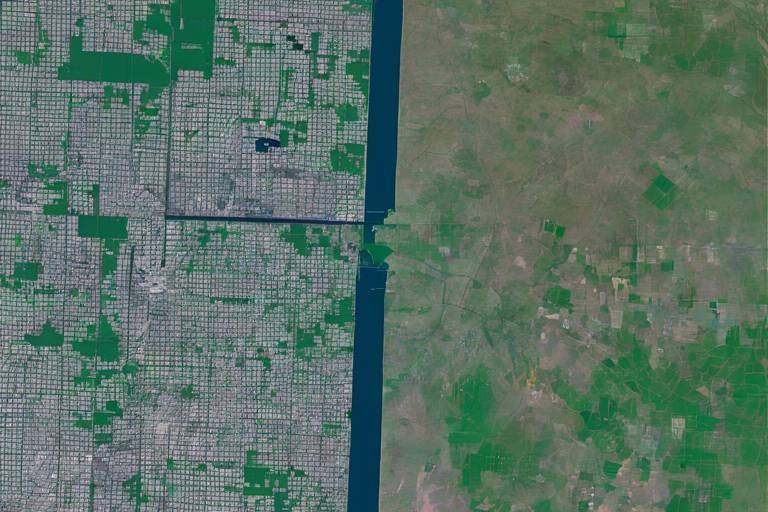
Remote sensing satellites are particularly fascinating. They gather information by detecting electromagnetic radiation reflected or emitted from the Earth's surface. This process allows scientists to monitor changes in land use, vegetation cover, and even water bodies. For example, a remote sensing satellite can capture images that reveal the extent of deforestation in a rainforest, helping conservationists and policymakers take action before it's too late.
On the other hand, communication satellites ensure that the data collected from these remote sensing missions is shared promptly with researchers and decision-makers. They play a vital role in creating a network where information flows seamlessly. Think of them as the postal service of the satellite world, delivering critical data to those who need it most. This rapid dissemination of information is especially crucial during environmental crises, where timely decisions can save lives and resources.
As we delve deeper into the capabilities of satellite technology, it's essential to recognize that the data they provide is only as good as the methods used to analyze it. Advanced algorithms and machine learning techniques are employed to interpret the vast amounts of data gathered, transforming raw numbers into actionable insights. This combination of cutting-edge technology and human expertise is what makes satellite monitoring such a powerful tool in the fight for environmental security.
In summary, the evolution of satellite technology has paved the way for unprecedented monitoring of our planet. From observing climate change to managing natural resources, satellites are integral to our understanding of environmental dynamics. As we continue to innovate and improve these technologies, the potential for enhancing environmental security becomes even more promising.
Types of Satellites
When we think about satellites, it's easy to imagine shiny metal objects orbiting our planet, beaming data back to Earth. But did you know that not all satellites are created equal? Each type of satellite serves a unique purpose, contributing to our understanding of the world in different ways. Let's dive into a few categories of satellites and uncover their roles in environmental monitoring.
First up, we have remote sensing satellites. These technological marvels are equipped with sensors that collect data about the Earth's surface from space. Imagine them as the eyes in the sky, capturing images and measuring various environmental factors. They help us monitor changes in land use, track deforestation, and assess the health of ecosystems. For instance, NASA's Landsat satellites have been pivotal in providing continuous data on land cover changes over several decades.
Next, we have communication satellites. While they may not directly monitor environmental changes, they play a crucial role in disseminating the information gathered by other satellites. These satellites facilitate real-time data sharing among researchers, policymakers, and emergency responders. Think of them as the postal service of satellite data, ensuring that vital information reaches those who need it most, especially during crises like natural disasters.
In addition to these, we also have weather satellites, which are essential for predicting climate patterns and severe weather events. These satellites monitor atmospheric conditions, providing critical data that helps meteorologists forecast storms, hurricanes, and other weather phenomena. This information is invaluable for disaster preparedness, allowing communities to brace for impact.
Another fascinating type is Earth observation satellites. These are specifically designed to study our planet's natural resources, such as water bodies, forests, and agricultural lands. By analyzing the data collected from these satellites, scientists can make informed decisions about resource management and conservation efforts. For example, the European Space Agency's Sentinel satellites are part of the Copernicus program, which focuses on environmental monitoring and sustainability.
To summarize, the diverse types of satellites—remote sensing, communication, weather, and Earth observation—each play a vital role in enhancing our understanding of environmental changes. By working together, they create a comprehensive picture of our planet's health, allowing us to respond effectively to the challenges we face.
Remote Sensing Satellites
Remote sensing satellites are like the eyes in the sky, constantly observing and gathering vital information about our planet. These technological marvels play a crucial role in environmental monitoring by collecting data that helps us understand changes in land use, vegetation patterns, and even climate dynamics. Imagine being able to see the Earth from space, capturing images that reveal the hidden stories of our ecosystems and how they are evolving over time. This capability is not just fascinating; it’s essential for making informed decisions regarding environmental security.
Equipped with advanced sensors and imaging technology, remote sensing satellites can capture detailed images of the Earth’s surface in various wavelengths of light. This allows scientists to analyze different characteristics of the land, such as soil moisture, vegetation health, and urban development. For instance, by using infrared imagery, these satellites can detect the health of crops, helping farmers optimize their yields and manage resources more efficiently. The data collected can be processed to create stunning visual representations, such as maps and graphs, which are invaluable for researchers and policymakers alike.
Moreover, remote sensing satellites provide a continuous stream of data, enabling real-time monitoring of environmental changes. This is particularly important for tracking deforestation, where satellite imagery can show the rapid loss of forest cover over time. Such insights can lead to immediate action, whether it’s implementing conservation strategies or enforcing regulations to protect endangered ecosystems. The ability to monitor these changes from space not only enhances our understanding but also empowers us to take proactive measures to safeguard our environment.
To illustrate the impact of remote sensing satellites, consider the following table that outlines some of their key applications:
| Application | Description |
|---|---|
| Land Use Mapping | Identifying changes in land usage, such as urban development or agricultural expansion. |
| Vegetation Analysis | Monitoring plant health and biomass, crucial for understanding ecosystem dynamics. |
| Climate Monitoring | Tracking changes in temperature and precipitation patterns to assess climate change impacts. |
| Disaster Management | Providing timely data for natural disasters, aiding in emergency response and recovery. |
In conclusion, remote sensing satellites are indispensable tools in our quest for environmental security. They enable us to visualize and analyze the changes occurring on our planet, helping us to respond effectively to environmental challenges. As technology continues to advance, the capabilities of these satellites will expand, offering even more precise and comprehensive data to protect our ecosystems and ensure a sustainable future.
Communication Satellites
Communication satellites are the unsung heroes in the realm of environmental monitoring. These technological marvels orbit the Earth, acting as crucial conduits for transmitting data across vast distances. Imagine them as the busy postmen of space, tirelessly delivering vital information from the planet's surface to researchers, policymakers, and emergency responders. Their role is not just about sending signals; it’s about ensuring that the right information reaches the right people at the right time, especially when it comes to environmental crises.
These satellites enable real-time data sharing, which is essential for effective decision-making. For instance, during a natural disaster, communication satellites allow emergency services to coordinate their responses and allocate resources efficiently. They provide the infrastructure that supports communication networks, ensuring that even in the most remote areas, vital information can flow seamlessly. This capability can mean the difference between life and death in disaster-stricken regions.
Moreover, communication satellites facilitate the collection and dissemination of environmental data from various sources, including remote sensing satellites. This integration of data sources enhances our understanding of environmental changes and threats. By transmitting data on weather patterns, deforestation rates, and pollution levels, these satellites help create a comprehensive picture of the planet's health. This information is invaluable for scientists and environmentalists who are working tirelessly to combat climate change and protect our ecosystems.
The importance of communication satellites extends beyond immediate disaster response. They also play a significant role in long-term environmental monitoring and research. For example, by providing continuous data streams, these satellites help track trends over time, allowing for better forecasting and planning. This capability is essential for developing strategies to mitigate the impacts of climate change and for ensuring sustainable resource management.
In summary, communication satellites are pivotal in the fight for environmental security. They not only enhance our ability to respond to immediate threats but also contribute to our understanding of long-term environmental trends. As technology advances, we can expect these satellites to become even more integral to our efforts in safeguarding the planet.
- What are communication satellites used for?
Communication satellites are primarily used to transmit data, voice, and video signals. They facilitate communication for television broadcasts, internet services, and emergency response systems, especially during natural disasters.
- How do communication satellites impact environmental monitoring?
They provide essential data transmission capabilities that allow researchers and policymakers to access real-time environmental data, which is crucial for monitoring changes and responding to environmental threats.
- Can communication satellites help during natural disasters?
Yes, they play a critical role in disaster response by enabling communication among emergency services and providing real-time data that can guide rescue and recovery operations.
Data Collection and Analysis
When it comes to monitoring our planet, satellites are like the eyes in the sky, capturing a wealth of information that is crucial for understanding environmental changes. But how exactly do they collect and analyze all this data? The process is fascinating and involves several sophisticated technologies and methodologies. First off, satellites equipped with various sensors orbit the Earth, continuously gathering data on everything from temperature variations to vegetation cover. This data is collected in real-time, allowing scientists and researchers to monitor changes as they happen.
Once the data is collected, the real magic happens. The raw data transmitted from satellites is often vast and complex, requiring advanced processing techniques to make sense of it all. This is where algorithms and machine learning come into play. These technologies help in filtering out noise and identifying meaningful patterns within the data. For example, when monitoring deforestation, algorithms can analyze satellite images over time to highlight areas of significant change. This allows for a clearer understanding of how human activities are impacting forests and ecosystems.
To give you a clearer picture, let's take a look at the types of data commonly collected by satellites:
| Type of Data | Description |
|---|---|
| Imagery | High-resolution images of the Earth's surface for land use and vegetation analysis. |
| Temperature | Data on surface temperatures to track climate variations. |
| Atmospheric Composition | Measurements of greenhouse gases and pollutants in the atmosphere. |
| Soil Moisture | Information on soil moisture levels to assess agricultural health. |
This data is not just numbers and images; it tells a story about our planet's health and the impacts of climate change. By analyzing trends over time, scientists can predict future changes and develop strategies to mitigate negative effects. For instance, satellite data has been crucial in understanding the rate of ice melt in polar regions, which directly correlates with rising sea levels. This kind of analysis provides invaluable insights that help policymakers make informed decisions regarding environmental protection and sustainability.
Moreover, the integration of satellite data with ground-based observations enhances the reliability of the findings. By combining these two sources of information, researchers can create a more comprehensive view of environmental changes, leading to more effective responses to issues like natural disasters or habitat loss. As we continue to develop new technologies and improve existing ones, the potential for satellite data to inform our understanding of environmental security will only grow stronger.
- How do satellites collect data? Satellites collect data using various sensors that capture images, temperature readings, and atmospheric measurements as they orbit the Earth.
- What happens to the data once it's collected? The raw data is transmitted to ground stations, where it undergoes processing and analysis using advanced algorithms and machine learning techniques.
- Why is satellite data important for environmental monitoring? Satellite data provides real-time information that helps scientists track changes in the environment, assess human impact, and inform policy decisions.
- Can satellite data predict natural disasters? While satellites can't predict disasters with absolute certainty, they provide critical data that can help in early warning systems and disaster preparedness.
Applications in Climate Change Monitoring
In the fight against climate change, satellites have emerged as our vigilant eyes in the sky, offering invaluable insights that help us understand and combat this pressing global issue. By continuously monitoring the Earth's surface and atmosphere, these technological marvels provide critical data that informs policy decisions, scientific research, and public awareness. Imagine trying to predict the weather without a forecast; it would be nearly impossible! Similarly, without satellite data, our understanding of climate change would be severely limited.
One of the primary applications of satellite technology in climate change monitoring is the ability to track temperature changes across the globe. Satellites equipped with advanced sensors can measure surface temperatures with remarkable precision. For instance, the Moderate Resolution Imaging Spectroradiometer (MODIS), aboard NASA's Terra and Aqua satellites, collects data that helps scientists analyze temperature trends over time. This information is crucial for identifying hot spots and understanding how different regions are affected by climate change.
Furthermore, satellites play a pivotal role in monitoring the melting of polar ice caps and glaciers. The European Space Agency's CryoSat mission, for example, uses radar altimetry to measure the thickness of ice, providing essential data on how much ice is being lost to rising temperatures. This isn't just a number; it has profound implications for global sea levels. As ice melts, it contributes to rising sea levels, which can lead to flooding in coastal communities around the world. The data gathered by satellites helps us predict these changes and prepare accordingly.
Another critical area where satellites shine is in observing changes in vegetation and land use. Remote sensing satellites can capture images that reveal deforestation rates, agricultural expansion, and urbanization. For example, the Sentinel-2 satellites, part of the Copernicus program, provide high-resolution images that allow researchers to monitor forest cover and assess the health of ecosystems. This information is vital for understanding how human activities contribute to carbon emissions and climate change.
Additionally, satellites are instrumental in tracking greenhouse gas emissions. They can measure the concentration of gases such as carbon dioxide and methane in the atmosphere. The Orbiting Carbon Observatory-2 (OCO-2) satellite, for instance, uses spectrometry to provide detailed maps of carbon dioxide levels. This data is essential for understanding the sources of emissions and evaluating the effectiveness of policies aimed at reducing greenhouse gases. With this information, policymakers can make informed decisions that directly impact climate change mitigation strategies.
Moreover, satellites are invaluable during natural disasters, which are becoming increasingly frequent and severe due to climate change. They provide real-time data that helps emergency responders assess damage, coordinate relief efforts, and monitor recovery. For example, during hurricanes, satellites can track storm paths and intensity, allowing for timely evacuations and resource allocation. This capability not only saves lives but also helps communities rebuild more resiliently.
As we look to the future, the role of satellites in climate change monitoring will only grow more significant. With advancements in technology, we can expect even more sophisticated satellites that will provide deeper insights into our changing planet. The integration of artificial intelligence and machine learning with satellite data analysis will enhance our ability to predict climate trends and respond effectively. In a world where climate change is one of the greatest challenges we face, these technological advancements will be crucial in safeguarding our planet for future generations.
- How do satellites measure temperature changes?
Satellites use advanced sensors to capture thermal infrared radiation emitted by the Earth's surface, allowing scientists to analyze temperature variations over time. - What is the significance of tracking greenhouse gas emissions?
Monitoring greenhouse gas emissions helps assess human impact on climate change and informs policies aimed at reducing these emissions. - Can satellites predict natural disasters?
While satellites cannot predict disasters with absolute certainty, they provide critical data that helps forecast storm paths and intensity, aiding in disaster preparedness.
Tracking Greenhouse Gas Emissions
Tracking greenhouse gas emissions is not just a scientific endeavor; it is a necessity for our planet's future. As we grapple with the realities of climate change, understanding the sources and concentrations of these gases becomes crucial. Satellites have emerged as powerful tools in this fight, providing a bird's-eye view of emissions across the globe. Imagine being able to observe the invisible gases that contribute to global warming from space—this is exactly what modern satellite technology enables us to do.
Satellites equipped with advanced sensors can measure the concentrations of greenhouse gases, such as carbon dioxide (CO2) and methane (CH4), in the atmosphere. By analyzing this data, scientists can identify emission hotspots, track changes over time, and assess the effectiveness of policies aimed at reducing emissions. For instance, the NASA Atmospheric Infrared Sounder (AIRS) onboard the Aqua satellite has been instrumental in monitoring CO2 levels, providing valuable insights into how human activities alter our atmosphere.
Furthermore, the data collected from these satellites can be visualized in various ways, making complex information more accessible. For example, a color-coded map can illustrate regions with high concentrations of greenhouse gases, enabling policymakers to focus their efforts where they are needed most. This is not just about collecting data; it's about translating that data into actionable insights. The following table highlights some key satellites and their contributions to tracking greenhouse gas emissions:
| Satellite | Agency | Key Features |
|---|---|---|
| Aqua | NASA | Monitors water vapor and greenhouse gases |
| Sentinel-5P | ESA | Measures air quality and greenhouse gas concentrations |
| OCO-2 | NASA | Specifically designed to measure atmospheric CO2 |
| GOSAT | JAXA | Tracks greenhouse gas emissions globally |
Moreover, the integration of satellite data with ground-based observations enhances the accuracy of emissions tracking. By combining these datasets, scientists can create a comprehensive picture of greenhouse gas emissions, allowing for better modeling and forecasting of future trends. This synergy between satellite and ground data is akin to putting together pieces of a puzzle—each piece adds clarity to the overall image of our planet's health.
In conclusion, tracking greenhouse gas emissions via satellites is a game changer in our battle against climate change. These high-tech eyes in the sky are not just collecting data; they are providing us with the insights needed to make informed decisions for a sustainable future. As we continue to refine these technologies, the potential for more precise tracking and effective policy implementation will only grow, making our efforts to combat climate change more robust and impactful.
- How do satellites measure greenhouse gas emissions?
Satellites use specialized sensors that detect specific wavelengths of light absorbed by greenhouse gases. By analyzing the intensity of this light, scientists can determine the concentration of these gases in the atmosphere. - What are the main greenhouse gases monitored by satellites?
The primary greenhouse gases monitored include carbon dioxide (CO2), methane (CH4), and nitrous oxide (N2O). Each of these gases has a significant impact on global warming. - Can satellite data influence policy decisions?
Absolutely! Satellite data provides crucial evidence that can support or challenge existing policies, helping governments to make more informed decisions regarding environmental regulations and climate action.
Monitoring Natural Disasters
Natural disasters can strike at any moment, often leaving devastation in their wake. The unpredictability of events like hurricanes, earthquakes, and wildfires poses significant challenges for communities and governments alike. However, thanks to the power of satellite technology, we have a robust tool at our disposal to monitor these calamities in real-time. By utilizing satellites, we can gather critical data that informs disaster preparedness, response, and recovery efforts.
One of the most remarkable features of satellites is their ability to capture extensive data from space, which can be transformed into actionable insights. For instance, during a hurricane, satellites can track the storm's path, intensity, and potential landfall locations. This information is crucial for issuing timely warnings and evacuations, potentially saving countless lives. But how exactly do satellites contribute to disaster monitoring? Let’s break it down:
- Real-time Imaging: Satellites equipped with high-resolution cameras can provide images of affected areas almost instantly. This capability allows for rapid assessments of damage and helps emergency responders prioritize their efforts.
- Weather Tracking: Specialized satellites monitor atmospheric conditions, providing data on temperature, humidity, and wind patterns that are essential for predicting severe weather events.
- Geospatial Analysis: By analyzing satellite imagery over time, we can identify changes in landscapes, such as deforestation or urban sprawl, which may exacerbate the impact of natural disasters.
Moreover, satellites are not just useful during disasters; they also play a crucial role in the recovery phase. After a disaster strikes, satellite data can help assess the extent of the damage, guiding relief efforts and resource allocation. For example, if a region suffers from flooding, satellites can provide detailed maps of the inundated areas, enabling rescue teams to navigate effectively. Similarly, in the aftermath of an earthquake, satellites can help visualize structural damage, allowing for better planning in rebuilding efforts.
As we look to the future, the integration of artificial intelligence and machine learning with satellite data is set to revolutionize disaster monitoring even further. Imagine a system that not only tracks natural disasters but also predicts them with greater accuracy. This could dramatically enhance our ability to prepare for and respond to these unpredictable events, ultimately leading to a safer and more resilient world.
In summary, satellites are indispensable in monitoring natural disasters. Their ability to provide real-time data and insights significantly enhances our preparedness and response capabilities. As technology continues to evolve, we can expect even greater advancements in satellite monitoring, paving the way for innovative solutions to tackle the challenges posed by natural disasters.
Q: How do satellites help in disaster response?
A: Satellites provide real-time imaging, weather tracking, and geospatial analysis, which are crucial for assessing damage and coordinating emergency responses.
Q: Can satellites predict natural disasters?
A: While satellites cannot predict disasters with absolute certainty, they can monitor environmental conditions that may indicate an impending disaster, allowing for better preparedness.
Q: What types of satellites are used for monitoring natural disasters?
A: Remote sensing satellites, weather satellites, and communication satellites all play vital roles in disaster monitoring and response.
The Future of Satellite Monitoring
As we look ahead, the future of satellite monitoring appears not only promising but also essential in our quest for environmental security. With rapid advancements in technology, we are on the brink of a new era where satellites will play an even more pivotal role in understanding and protecting our planet. Imagine a world where satellites can provide real-time data with unprecedented accuracy—this is not just a dream; it’s becoming a reality. The integration of artificial intelligence (AI) and machine learning into satellite technology is set to revolutionize how we collect and analyze environmental data.
One of the most exciting prospects is the potential for miniaturization of satellite technology. Smaller, more agile satellites, often referred to as nanosatellites or CubeSats, can be launched in swarms to gather data from multiple locations simultaneously. This could lead to a dramatic increase in the frequency and precision of environmental monitoring. For instance, a network of small satellites could continuously track deforestation rates, providing critical data to policymakers and conservationists in real-time.
Moreover, advancements in sensor technology will enhance our ability to monitor various environmental parameters. Future satellites are expected to be equipped with more sophisticated sensors that can detect a wider range of wavelengths, allowing for better analysis of vegetation health, water quality, and even air pollution levels. This capability will enable scientists to create more accurate models of ecological changes and predict potential environmental crises before they occur.
Another promising development is the potential for improved data-sharing platforms. As the volume of satellite data grows, so does the need for efficient systems to manage and disseminate this information. Collaborative platforms that integrate data from multiple satellites and sources will allow researchers, governments, and NGOs to access vital information quickly. This could facilitate more effective responses to environmental challenges, from climate change to natural disasters.
In addition to technological advancements, the future of satellite monitoring will also rely heavily on international cooperation. Environmental issues are global challenges that transcend borders, and a collaborative approach will be crucial in addressing them. By sharing data and resources, countries can work together to develop comprehensive strategies for environmental protection and disaster response. This collaborative spirit can be likened to a team sport, where each player contributes their strengths to achieve a common goal—protecting our planet.
In conclusion, the future of satellite monitoring is bright, filled with opportunities for innovation and collaboration. As we harness the power of technology and data, we can enhance our understanding of environmental security and take meaningful steps toward a sustainable future. The question remains, are we ready to embrace these changes and act on the information provided by our satellites? The answer lies in our commitment to protecting the Earth and ensuring a healthy environment for generations to come.
- What advancements in technology are expected in satellite monitoring?
Future satellites will likely feature advanced sensors, AI integration, and miniaturization, allowing for more accurate and efficient data collection. - How can satellites help in disaster response?
Satellites provide real-time data during natural disasters, aiding in preparedness, response, and recovery efforts. - What role does international cooperation play in satellite monitoring?
Collaborative efforts among countries can enhance data sharing and resource allocation, leading to more effective environmental protection strategies.
Frequently Asked Questions
- What is environmental security?
Environmental security refers to the protection of ecosystems and human health from environmental threats. It's crucial for ensuring global stability and sustainability, as it addresses issues like climate change, deforestation, and pollution.
- How do satellites contribute to monitoring climate change?
Satellites play a vital role in tracking climate change by collecting data on temperature rises, ice melt, and sea-level changes. They provide comprehensive insights that help scientists understand the impact of human activities on the environment.
- What types of satellites are used for environmental monitoring?
There are several types of satellites used in environmental monitoring, including remote sensing satellites, which capture images of the Earth's surface, and communication satellites, which facilitate real-time data sharing among researchers and policymakers.
- How do remote sensing satellites work?
Remote sensing satellites collect data by capturing images of the Earth's surface from space. They analyze changes in land use, vegetation, and other environmental factors, providing critical information for monitoring and managing natural resources.
- Can satellites track greenhouse gas emissions?
Yes, satellites are equipped to measure greenhouse gas concentrations in the atmosphere. This data is essential for assessing human impact on climate change and developing strategies to mitigate its effects.
- What role do satellites play during natural disasters?
Satellites provide crucial information during natural disasters by monitoring conditions and offering real-time data for disaster preparedness, response, and recovery efforts. They help coordinate rescue operations and assess damage after events like hurricanes and wildfires.
- What advancements can we expect in satellite technology?
As technology continues to evolve, we can expect significant advancements in satellite capabilities. Future satellites may provide even more precise data, enhance monitoring of environmental changes, and improve our ability to respond to ecological threats.


