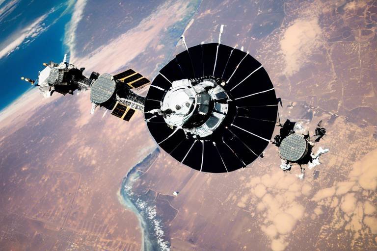
How Satellites Aid in Humanitarian Assistance Missions
In our fast-paced world, the need for effective humanitarian assistance has never been more critical. When disasters strike, whether they are natural calamities like earthquakes and floods or man-made crises such as conflicts, the ability to respond swiftly can mean the difference between life and death. This is where satellites come into play. They serve as the unsung heroes in the realm of disaster response, providing vital information that enhances our ability to deliver aid efficiently and effectively. Imagine being able to see the devastation from space, pinpointing the hardest-hit areas, and coordinating relief efforts with unprecedented precision. That’s the power of satellite technology!
Satellites are equipped with advanced imaging capabilities that allow them to capture high-resolution images of the Earth. These images are crucial for assessing damage in real-time, enabling humanitarian organizations to prioritize their response efforts. For instance, when a hurricane makes landfall, satellite imagery can reveal which areas have been flooded or damaged, allowing responders to deploy resources where they are needed most. It’s like having a bird's-eye view of a disaster zone, giving aid workers the information they need to act swiftly.
Moreover, the data collected by satellites is not just about observing the aftermath; it also plays a significant role in the prevention and planning stages. By monitoring environmental changes—such as shifts in climate patterns or the encroachment of deforestation—satellites help predict potential humanitarian crises before they escalate. This proactive approach enables organizations to prepare for and mitigate the effects of disasters, ensuring that they are ready to respond when the time comes.
In addition to disaster monitoring, satellites enhance logistics and supply chain management. Imagine trying to deliver aid to a remote village that has been cut off by a flood. Without accurate maps and tracking capabilities, this task becomes incredibly challenging. However, with satellite technology, humanitarian agencies can create detailed maps that guide them through treacherous terrain, ensuring that supplies reach those in need without unnecessary delays. This logistical support is crucial, especially in times of crisis when every moment counts.
As we delve deeper into the role of satellites in humanitarian missions, we will explore specific case studies that highlight their effectiveness. From conflict zones where traditional aid delivery methods are hindered to collaborative efforts with non-governmental organizations (NGOs) that leverage satellite technology, the impact of satellites in humanitarian assistance is profound and far-reaching. Stay tuned as we uncover the stories behind the technology that is changing the landscape of disaster response.
- How do satellites gather data during a disaster?
Satellites use various imaging technologies, such as optical and radar sensors, to capture detailed images of affected areas, providing crucial information for assessment and response. - Can satellites predict disasters?
While satellites cannot predict disasters with absolute certainty, they monitor environmental changes that can indicate potential crises, allowing for better preparedness. - What role do NGOs play in using satellite data?
NGOs often collaborate with satellite technology providers to access real-time data, enhancing their ability to deliver aid effectively in crisis situations. - Are satellites used only for natural disasters?
Not at all! Satellites are also instrumental in monitoring humanitarian needs in conflict zones, providing vital information for aid delivery.
The Role of Satellites in Disaster Response
When disaster strikes, whether it’s a massive earthquake, a hurricane, or a flood, the immediate aftermath is often chaos. In such critical moments, the role of satellites becomes invaluable. They act as our eyes in the sky, providing crucial information that helps responders assess the situation quickly and accurately. Imagine trying to navigate a maze blindfolded; that’s what disaster response would be like without satellite data. With satellite imagery, humanitarian organizations can evaluate the extent of damage, pinpoint affected areas, and prioritize their response efforts.
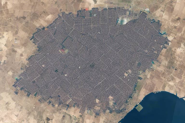
One of the most significant advantages of satellite technology is its ability to capture high-resolution images of disaster-stricken regions. This imagery can be processed and analyzed to create detailed maps that show the impact of the disaster. For instance, after a flood, satellites can reveal which areas are submerged and which roads are impassable. This information is crucial for planning rescue operations and delivering aid where it’s needed most.
Furthermore, satellites provide a comprehensive view of the disaster zone, allowing responders to see beyond the immediate vicinity. This capability is especially beneficial in remote or hard-to-reach areas where ground assessments may be challenging or impossible. With the data gathered from satellites, organizations can create a clearer picture of the overall situation, enabling them to allocate resources more effectively. For example, if certain regions are identified as severely affected, more supplies and personnel can be directed there without wasting time and resources on less impacted areas.
Additionally, the speed at which satellite data can be collected and disseminated is critical in disaster response. In many cases, satellite imagery can be available within hours of a disaster occurring. This rapid response is essential, as the first few days following a disaster are often the most crucial for saving lives and providing necessary aid. Humanitarian organizations can utilize this timely information to mobilize their resources, coordinate with local authorities, and establish communication lines with affected communities.
In summary, satellites play a pivotal role in disaster response by:
- Providing real-time imagery for damage assessment.
- Offering a comprehensive view of affected areas.
- Enabling quick and informed decision-making.
- Facilitating effective resource allocation and logistics planning.
As we continue to face natural disasters exacerbated by climate change, the importance of satellite technology in humanitarian missions will only grow. By harnessing the power of satellites, we can enhance our response capabilities, ultimately saving more lives and ensuring that aid reaches those who need it most.
Real-Time Data for Effective Decision-Making
In the fast-paced world of humanitarian assistance, real-time data is nothing short of a lifeline. Imagine being in the midst of a disaster, where every second counts, and the difference between life and death hinges on timely information. This is where satellites come into play, providing a continuous stream of data that informs crucial decisions. By leveraging satellite technology, humanitarian organizations can access real-time imagery and information that helps them understand the evolving situation on the ground.
One of the most significant advantages of real-time satellite data is its ability to facilitate rapid assessment of disaster scenarios. For instance, when a natural disaster strikes, organizations can quickly analyze satellite images to determine the extent of the damage. This type of immediate feedback allows aid agencies to prioritize their response efforts effectively. They can allocate resources to the hardest-hit areas, ensuring that help reaches those who need it most without delay.
Moreover, real-time data enhances coordination among various stakeholders. Humanitarian missions often involve multiple organizations working together, each with its own set of goals and resources. By utilizing satellite data, these entities can synchronize their efforts, share information, and avoid duplication of services. This collaborative approach not only streamlines operations but also maximizes the impact of the aid being delivered.
Another crucial aspect of real-time data is its role in resource allocation. Humanitarian organizations must make informed decisions about where to send supplies and personnel. With satellite imagery, they can visualize areas that require immediate attention, such as regions cut off from traditional supply routes due to flooding or landslides. This data-driven strategy ensures that resources are directed where they are most needed, ultimately saving more lives.
But how exactly does this process work? Let's break it down:
- Data Collection: Satellites continuously collect data from various sensors, capturing images and information about weather patterns, land use, and infrastructure.
- Data Analysis: Advanced algorithms process this data, identifying changes and anomalies that signal a potential crisis.
- Information Dissemination: The analyzed data is then shared with humanitarian organizations in real-time, allowing them to act swiftly.
To illustrate the effectiveness of real-time satellite data, consider the following example: during the 2010 Haiti earthquake, satellite imagery was crucial for assessing the damage and planning the relief response. Organizations like the World Food Programme utilized this data to map out affected areas, ensuring that food and medical supplies reached those in dire need without unnecessary delays.
In conclusion, the role of real-time data in humanitarian decision-making cannot be overstated. It empowers organizations to act quickly, coordinate effectively, and allocate resources efficiently, all of which are vital in saving lives during crises. As technology continues to evolve, the integration of satellite data into humanitarian missions will undoubtedly enhance our ability to respond to disasters and support vulnerable populations around the globe.
- How does satellite data improve disaster response?
Satellite data provides real-time information that helps organizations assess damage and prioritize aid delivery, ensuring timely assistance to those in need. - Can satellite imagery be used in conflict zones?
Yes, satellite imagery is invaluable in conflict zones as it helps monitor humanitarian needs and facilitates the delivery of aid despite challenging conditions. - What types of data do satellites collect?
Satellites collect various types of data, including weather patterns, land use, and infrastructure changes, which are critical for effective decision-making during humanitarian missions.
Monitoring Environmental Changes
In an era where environmental shifts are becoming increasingly pronounced, satellites serve as our eyes in the sky, constantly observing and analyzing the Earth's surface. These high-tech tools are not just for taking pretty pictures; they play a crucial role in monitoring environmental changes that can lead to humanitarian crises. Imagine a world where we can predict the onset of droughts or floods before they wreak havoc on communities. That’s the power of satellite technology!
Satellites are equipped with sophisticated sensors that collect data on various environmental factors, including temperature, vegetation health, and land use changes. For instance, by analyzing satellite imagery, scientists can track deforestation rates in real-time, which is essential for understanding how these changes impact biodiversity and local communities. When forests are cut down, not only do we lose precious ecosystems, but we also increase the risk of landslides and soil erosion, which can endanger lives.
Moreover, satellites can observe climate patterns and their fluctuations. This capability is vital for forecasting events such as hurricanes, which can devastate entire regions. By providing early warnings, satellites enable humanitarian organizations to prepare and respond effectively. This proactive approach can mean the difference between life and death for many vulnerable populations. The data collected can be synthesized into actionable insights, allowing aid agencies to allocate resources where they are most needed.
To illustrate the impact of satellite monitoring, consider the following table that summarizes key environmental changes tracked by satellite technology:
| Environmental Change | Satellite Technology Used | Impact on Humanitarian Efforts |
|---|---|---|
| Deforestation | Optical and Radar Satellites | Identifies areas at risk, enabling targeted reforestation efforts. |
| Climate Change | Climate Monitoring Satellites | Tracks temperature changes and extreme weather patterns. |
| Soil Degradation | Multispectral and Hyperspectral Imaging | Helps in assessing agricultural productivity and food security. |
| Water Resources | Remote Sensing Technology | Monitors water levels in lakes and rivers, crucial for drought management. |
In conclusion, monitoring environmental changes through satellites is not just about collecting data; it’s about transforming that data into actionable strategies that can save lives and enhance community resilience. As we continue to face environmental challenges, the role of satellites becomes more critical than ever. They equip us with the knowledge to respond to crises before they escalate, ensuring that humanitarian aid can reach those in need swiftly and effectively.
- How do satellites monitor environmental changes?
Satellites use various sensors to gather data on temperature, vegetation, land use, and other environmental factors, allowing for real-time monitoring. - What are the benefits of using satellites in humanitarian missions?
Satellites provide critical data for disaster prediction, damage assessment, and resource allocation, enhancing the efficiency of humanitarian efforts. - Can satellites predict natural disasters?
While satellites cannot predict disasters with absolute certainty, they can provide early warnings by monitoring environmental changes that precede such events.
Tracking Natural Disasters
When it comes to tracking natural disasters, satellites are like the superheroes of the sky, swooping in to provide critical data that can save lives. Imagine being able to see a hurricane brewing in the ocean long before it makes landfall or detecting an earthquake's tremors just moments after they occur. This is the power of satellite technology, which utilizes advanced sensors and imaging techniques to monitor natural events in real-time.
One of the most remarkable aspects of satellite tracking is its ability to offer early warning systems. These systems are crucial in mitigating the effects of disasters. For instance, satellites can detect changes in weather patterns, such as the formation of tropical storms. When these storms are identified, meteorologists can issue warnings to communities at risk, allowing them to prepare and evacuate if necessary. This proactive approach can mean the difference between life and death.
Satellites use a variety of technologies to observe natural disasters. For example, radar satellites can penetrate cloud cover to capture images of storm systems, while optical satellites provide high-resolution images of the Earth’s surface. The data collected can be analyzed to predict the path of a storm or the likelihood of a flood. In fact, during the 2017 hurricane season, satellites played a pivotal role in tracking hurricanes like Harvey and Irma, providing critical information that helped emergency services respond effectively.
Moreover, the integration of satellite data with other technologies, such as Geographic Information Systems (GIS), enhances disaster tracking capabilities. By layering satellite imagery with population density maps, authorities can identify the most vulnerable areas and prioritize their response efforts. This synergy between technology and data not only improves situational awareness but also optimizes resource allocation, ensuring that aid reaches those who need it most.
In addition to hurricanes and floods, satellites are also invaluable for tracking wildfires. With the ability to monitor large areas in real-time, satellite imagery can detect hotspots and assess fire spread. This information is crucial for firefighting teams, enabling them to deploy resources efficiently and effectively. For example, during the catastrophic wildfires in California, satellite data provided insights into fire behavior, helping teams strategize their containment efforts.
As we look to the future, the evolution of satellite technology promises even greater advancements in disaster tracking. The advent of small satellites, or CubeSats, allows for more frequent and detailed observations at a lower cost. This opens up new possibilities for monitoring environmental changes and disaster risks, ultimately leading to better preparedness and response strategies.
In summary, tracking natural disasters through satellite technology is not just about observing events; it's about saving lives and protecting communities. The ability to provide timely, accurate information empowers decision-makers to act swiftly and effectively, transforming the way we respond to natural disasters.
Assessing Damage Post-Disaster
After a disaster strikes, the immediate aftermath can often feel like a chaotic whirlwind, leaving communities reeling and responders scrambling to understand the extent of the damage. This is where satellite imagery comes into play, acting as a bird's-eye view that cuts through the confusion. Imagine being able to see the devastation from above, pinpointing areas that need urgent help. This is not just a dream; it’s a reality thanks to advanced satellite technology. By capturing high-resolution images of affected regions, satellites provide invaluable data that helps humanitarian organizations assess damage quickly and accurately.
One of the key advantages of using satellites for damage assessment is their ability to cover vast areas in a short amount of time. Traditional ground surveys can take days or even weeks, but with satellites, responders can obtain a comprehensive overview almost instantly. For instance, following a major earthquake, satellite images can reveal not only the structural damage to buildings but also the state of critical infrastructure such as roads and bridges. This information is crucial for prioritizing areas that require immediate attention.
Moreover, satellite data can be analyzed to create detailed damage assessment reports that aid in the planning of recovery efforts. These reports often include:
- Damage Severity Levels: Categorizing the extent of damage from minor to severe.
- Infrastructure Impact: Identifying which essential services are disrupted.
- Population Displacement: Estimating the number of people affected and in need of assistance.
Additionally, satellites can also track changes over time, allowing organizations to monitor recovery progress. By comparing pre- and post-disaster images, responders can evaluate how effectively aid is being delivered and adjust their strategies accordingly. This adaptive approach ensures that resources are allocated where they are most needed, ultimately saving more lives.
In conclusion, the role of satellites in assessing damage post-disaster cannot be overstated. They provide a critical lens through which humanitarian organizations can view the impact of disasters, enabling them to act swiftly and effectively. As technology continues to evolve, we can only anticipate even greater advancements in satellite capabilities, paving the way for more efficient disaster response and recovery efforts.
Q1: How quickly can satellites assess damage after a disaster?
A1: Satellites can capture images within hours of a disaster, providing immediate data for assessment.
Q2: What type of satellite imagery is used for damage assessment?
A2: High-resolution optical and radar imagery are commonly used to evaluate structural damage and infrastructure impacts.
Q3: Are there any limitations to using satellite data for damage assessment?
A3: Yes, factors such as cloud cover, resolution limitations, and the need for ground validation can affect the accuracy of assessments.
Q4: How do humanitarian organizations utilize satellite data?
A4: Organizations use satellite data to prioritize response efforts, track recovery progress, and coordinate logistics for aid delivery.
Enhancing Logistics and Supply Chain Management
When disaster strikes, the clock is ticking, and every second counts. This is where satellites shine, transforming the chaos of humanitarian missions into a well-orchestrated symphony of logistics and supply chain management. Imagine trying to navigate a maze without a map; that’s what aid organizations face without the guidance that satellite technology offers. By providing detailed mapping and real-time tracking capabilities, satellites help humanitarian workers deliver supplies efficiently to those in dire need.
One of the most significant advantages of satellite technology is its ability to create precise geographic information systems (GIS) that aid in planning and executing relief efforts. For instance, during a natural disaster, NGOs can use satellite imagery to identify the most affected areas, allowing them to prioritize resources effectively. This capability is akin to having a bird’s eye view of a battlefield, where every move can be calculated and executed with precision. A well-planned logistics strategy ensures that food, water, medical supplies, and shelter reach the right people at the right time.
Furthermore, satellites facilitate the monitoring of transportation routes and infrastructure conditions. By analyzing real-time data, humanitarian organizations can avoid blocked roads, damaged bridges, or hazardous areas, ensuring that their delivery trucks take the safest and most efficient paths. This not only saves time but also reduces costs, enabling NGOs to allocate more resources directly to those in need. For example, during the aftermath of a hurricane, satellite data can reveal which roads are passable and which are not, allowing for quick adjustments to logistical plans.
In addition to mapping and tracking, satellites also play a crucial role in supply chain management. They enable organizations to maintain visibility over their inventory and shipments, ensuring that supplies are not only delivered but also tracked throughout the entire journey. This visibility is essential in preventing loss or waste, which can be detrimental in crisis situations. Imagine a situation where vital medical supplies are lost in transit; the consequences could be catastrophic. With satellite tracking, NGOs can monitor their shipments and respond swiftly to any issues that arise.
To illustrate the impact of satellite technology on logistics, consider the following table that highlights key benefits:
| Benefit | Description |
|---|---|
| Real-Time Tracking | Provides live updates on the location of supplies, ensuring timely delivery. |
| Route Optimization | Identifies the safest and most efficient routes for transportation. |
| Inventory Management | Helps organizations keep track of supplies and reduce waste. |
| Data-Driven Decisions | Enables informed decision-making based on accurate, real-time information. |
In conclusion, the integration of satellite technology into logistics and supply chain management is revolutionary for humanitarian missions. It not only enhances the efficiency of aid delivery but also ensures that organizations can respond swiftly and effectively in times of crisis. By leveraging real-time data and advanced mapping capabilities, NGOs can navigate the complexities of disaster response with greater confidence, ultimately saving lives and alleviating suffering in the most challenging circumstances.
- How do satellites improve disaster response?
Satellites provide critical information and real-time data that help assess damage, plan logistics, and coordinate relief efforts effectively. - What kind of data do satellites provide?
Satellites can provide imagery for mapping, tracking weather patterns, and monitoring environmental changes that may lead to humanitarian crises. - Can satellites help in conflict zones?
Yes, satellites play a crucial role in monitoring conditions and assessing humanitarian needs, enabling aid delivery even in challenging environments. - How do NGOs collaborate with satellite technology providers?
NGOs often partner with satellite companies to access data and tools that enhance their missions, leading to more effective humanitarian assistance.
Case Studies of Satellite Use in Humanitarian Aid
When we think about humanitarian aid, it's easy to picture volunteers delivering food and supplies to those in need. But behind the scenes, there's a powerful ally working tirelessly: satellite technology. The following case studies illustrate how satellites have transformed humanitarian missions, enabling organizations to respond swiftly and efficiently during crises.
One prominent example is the response to the devastating earthquake in Haiti in 2010. Following the disaster, satellite imagery was crucial in assessing the extent of the damage. Organizations like the United Nations and NASA utilized high-resolution satellite images to map out the affected areas, identifying the most severely impacted neighborhoods. This information allowed aid agencies to prioritize their efforts and direct resources to where they were needed most. The rapid assessment facilitated by satellites significantly sped up the delivery of essential services, such as medical care and shelter.
Another remarkable instance occurred during the Syrian refugee crisis. Satellite data has been instrumental in monitoring refugee movements and assessing their needs. Organizations like the World Food Programme have leveraged satellite technology to analyze population densities in refugee camps. This data helps them optimize food distribution, ensuring that aid reaches the most vulnerable populations. By tracking changes in the camps, humanitarian organizations can adapt their strategies in real-time, addressing emerging needs more effectively.
In conflict zones, such as Yemen, satellites have played a vital role in monitoring humanitarian conditions. The ongoing conflict has led to severe food insecurity, and satellite imagery has been used to assess agricultural land and crop health. By analyzing satellite data, organizations can identify areas at risk of famine and prioritize interventions. This proactive approach not only saves lives but also helps communities rebuild their livelihoods.
Moreover, the collaboration between non-governmental organizations (NGOs) and satellite technology providers has led to innovative solutions in humanitarian assistance. For instance, the partnership between Humanitarian OpenStreetMap Team (HOT) and various satellite companies has resulted in the creation of detailed maps for disaster-stricken areas. These maps are crucial for planning and executing relief operations, ensuring that aid reaches those who need it most, even in the most challenging environments.
In summary, the case studies highlighted above demonstrate the significant impact of satellites in humanitarian aid. From rapid damage assessments to real-time monitoring of refugee needs, satellite technology enhances the effectiveness of relief efforts. As we continue to face global challenges, the integration of satellite data into humanitarian missions will undoubtedly play a pivotal role in saving lives and alleviating suffering.
- How do satellites help in disaster response?
Satellites provide real-time imagery and data that enable organizations to assess damage quickly and coordinate response efforts efficiently. - What role do satellites play in monitoring environmental changes?
Satellites track climate patterns and deforestation, helping predict potential humanitarian crises and allowing for proactive planning. - Can satellite technology be used in conflict zones?
Yes, satellites are crucial in monitoring humanitarian needs in conflict areas, allowing for targeted aid delivery. - How do NGOs collaborate with satellite providers?
NGOs partner with satellite technology providers to enhance mapping and tracking capabilities, improving their operational effectiveness.
Satellite Applications in Conflict Zones
In the chaotic environment of conflict zones, where traditional methods of communication and information gathering often break down, satellites emerge as a beacon of hope. These high-tech tools are not just orbiting pieces of metal; they are essential lifelines that provide crucial data for humanitarian efforts. Imagine trying to navigate a stormy sea without a compass—this is what humanitarian organizations face without satellite technology. By offering real-time imagery and data, satellites enable NGOs and aid agencies to assess needs, plan interventions, and deliver assistance where it's most needed.
One of the most significant applications of satellites in conflict zones is their ability to monitor and map the humanitarian situation from above. For instance, satellite imagery can reveal displaced populations, damaged infrastructure, and even the movement of conflict. This information is invaluable for organizations like the United Nations and various NGOs, as it allows them to prioritize areas that require urgent attention. Without such insights, aid could be misallocated, leaving vulnerable populations without the help they desperately need.
Moreover, satellites help in assessing the security situation in conflict areas. By analyzing patterns of movement and gathering intelligence from high-resolution images, humanitarian agencies can make informed decisions about where to deploy resources and personnel. This proactive approach not only enhances the safety of aid workers but also ensures that assistance reaches those who need it most, even in the most dangerous circumstances.
Additionally, the integration of satellite data with other technologies, such as Geographic Information Systems (GIS), allows for a more comprehensive understanding of the situation on the ground. For example, GIS can overlay satellite imagery with data on population density, infrastructure, and access routes, creating a powerful tool for planning and executing humanitarian missions. This synergy between satellite technology and GIS enhances situational awareness, enabling organizations to respond more effectively to the evolving challenges in conflict zones.
However, the use of satellites in these areas is not without its challenges. Issues such as data accessibility, the need for advanced training, and the high costs of satellite services can hinder their full potential. Yet, the benefits far outweigh the drawbacks. As technology advances, we can expect more innovative solutions, such as smaller satellites and improved data analytics, making it easier for humanitarian organizations to leverage this powerful tool.
In conclusion, the applications of satellite technology in conflict zones are transformative. They not only provide critical information that can save lives but also empower humanitarian organizations to navigate the complexities of delivering aid in some of the world's most challenging environments. As we continue to rely on these technological advancements, the hope is that we can create a more efficient and responsive humanitarian system, ultimately leading to better outcomes for those affected by conflict.
- How do satellites help in conflict zones? Satellites provide real-time imagery and data that help humanitarian organizations assess needs, monitor security, and plan effective interventions.
- Can satellite data be accessed easily? While satellite data is crucial, accessibility can be a challenge due to costs and the need for specialized training to interpret the data effectively.
- What technologies are integrated with satellite data? Satellite data is often combined with Geographic Information Systems (GIS) to create a comprehensive view of the situation on the ground.
- Are there any limitations to using satellites in humanitarian efforts? Yes, challenges include data accessibility, high costs, and the need for advanced training to utilize satellite technology effectively.
Collaborative Efforts with NGOs
In the realm of humanitarian assistance, collaboration is often the key to success, and this is especially true when it comes to the partnership between non-governmental organizations (NGOs) and satellite technology providers. These alliances not only enhance the effectiveness of aid delivery but also ensure that resources are allocated where they are most needed. Imagine trying to navigate through a dense fog without a map; that’s how challenging it can be for NGOs to operate in disaster-stricken areas without the precise data that satellites can provide.
One of the most remarkable aspects of these collaborations is the ability to leverage real-time satellite imagery to assess needs and monitor conditions on the ground. For instance, NGOs working in conflict zones can utilize satellite data to identify areas that are most affected by violence or natural disasters. This means that instead of relying solely on reports from the field, they can have a bird's-eye view of the situation, allowing for a more informed and timely response. When organizations like Doctors Without Borders or the International Red Cross team up with satellite companies, they can optimize their operations and ensure that medical supplies, food, and other essential resources reach those who need them most.
Moreover, the partnership between NGOs and satellite technology providers often leads to the development of innovative solutions tailored to specific challenges. For example, during the 2015 Nepal earthquake, NGOs collaborated with satellite companies to create detailed maps that highlighted the most affected areas. This data was crucial for planning relief efforts and prioritizing resources. The result? A more coordinated response that saved countless lives. Such instances showcase the profound impact of these collaborations, transforming the way humanitarian missions are conducted.
Another critical aspect of these collaborations is the sharing of data. NGOs often have extensive knowledge of local contexts and needs, while satellite companies possess advanced technology and data analytics capabilities. When these two forces combine, they create a powerful synergy. For instance, organizations can provide feedback on satellite imagery to improve the accuracy of data interpretation. This two-way communication not only enhances the effectiveness of humanitarian efforts but also fosters a sense of community among stakeholders. It’s like a well-rehearsed orchestra, where each musician knows their part and works together to create a beautiful symphony of aid.
In conclusion, the collaborative efforts between NGOs and satellite technology providers are not just beneficial; they are essential for effective humanitarian assistance. By combining resources, expertise, and innovative technologies, these partnerships pave the way for a more efficient and impactful response to crises. The future of humanitarian aid is bright, thanks to these collaborations that continually push the boundaries of what is possible.
- What role do satellites play in humanitarian missions?
Satellites provide critical data and imagery that help NGOs assess damage, monitor environmental changes, and coordinate relief efforts effectively. - How do NGOs collaborate with satellite technology providers?
NGOs often partner with satellite companies to access real-time data, which enhances their ability to respond to crises and allocate resources efficiently. - Can satellite data improve disaster response times?
Yes, access to real-time satellite imagery allows humanitarian organizations to make informed decisions quickly, leading to faster response times in emergencies. - Are there any successful case studies of satellite use in humanitarian aid?
Yes, numerous case studies, such as the response to the 2015 Nepal earthquake, demonstrate how satellite technology has significantly improved disaster response and recovery efforts.
Frequently Asked Questions
- How do satellites assist in disaster response?
Satellites provide critical information during disasters by offering real-time imagery that helps assess damage and coordinate response efforts. This allows humanitarian organizations to quickly evaluate the extent of the disaster and deploy resources effectively.
- What kind of real-time data do satellites provide?
Satellites deliver a variety of real-time data, including weather patterns, land changes, and damage assessments. This information is vital for making informed decisions about where and how to allocate resources during a crisis.
- How do satellites monitor environmental changes?
Satellites continuously observe environmental changes, such as deforestation and climate fluctuations, which can lead to humanitarian crises. By analyzing this data, organizations can proactively plan for potential disasters and mitigate their impacts.
- What technology do satellites use to track natural disasters?
Satellites utilize advanced imaging and sensing technology to monitor natural disasters like hurricanes and earthquakes. These systems provide early warning signals, which are crucial for saving lives and facilitating timely evacuations.
- How is satellite imagery used post-disaster?
Post-disaster, satellite imagery is essential for assessing damage to infrastructure and communities. It helps humanitarian teams identify the most affected areas, enabling them to prioritize their recovery efforts and allocate resources efficiently.
- In what ways do satellites enhance logistics in humanitarian missions?
Satellites improve logistics by offering detailed mapping and tracking capabilities. This technology ensures that supplies reach affected areas quickly and efficiently, minimizing delays and maximizing the impact of aid efforts.
- Can you give examples of satellite use in humanitarian aid?
Certainly! There are numerous case studies where satellites have been instrumental. For instance, during the 2010 Haiti earthquake, satellite imagery was crucial for assessing damage and planning recovery. Another example includes the use of satellites in monitoring food security in conflict zones.
- How do NGOs collaborate with satellite technology providers?
NGOs often partner with satellite technology providers to enhance their missions. These collaborations result in improved data access and analysis, leading to more effective humanitarian assistance and better outcomes for affected communities.