The Role of Robotics in Urban Environmental Monitoring
This article explores how robotics technology is transforming urban environmental monitoring, enhancing data collection, and improving sustainability efforts in cities around the world.
Urban environmental monitoring is essential for understanding the impact of human activities on ecosystems. With cities expanding and populations increasing, the need for effective monitoring has never been more critical. Traditional methods, such as manual sampling and stationary sensors, often fall short in terms of coverage, speed, and data accuracy. These methods can be time-consuming, labor-intensive, and sometimes even dangerous, especially in hazardous environments. As urban areas face challenges like pollution, climate change, and resource depletion, the significance of modern monitoring techniques becomes increasingly clear.
Various types of robots, including drones and ground-based robots, are utilized for environmental monitoring. Each type of robotic technology offers unique advantages tailored to specific applications in urban settings. For instance, drones excel in aerial surveillance, while ground-based robots can navigate complex terrains and collect data from hard-to-reach areas. This versatility allows cities to gather comprehensive data, facilitating informed decision-making and proactive environmental management.
Drones are increasingly used for aerial surveillance, providing real-time data on air quality, vegetation health, and urban heat islands. The ability to cover vast areas quickly makes drones invaluable for urban planners and environmental scientists. They can capture high-resolution images and collect data on various environmental parameters, enabling a detailed analysis of urban ecosystems. However, while drones offer remarkable advantages, they are not without their limitations. Regulatory restrictions and technical challenges can hinder their widespread adoption in urban monitoring.
Drones can gather extensive data quickly over large areas, making them a game-changer in urban environmental assessments. They collect various types of data, including:
- Air quality measurements
- Thermal imaging for heat mapping
- Vegetation indices for assessing plant health
This wealth of information contributes significantly to understanding urban ecosystems and making data-driven decisions that enhance sustainability efforts.
Despite their benefits, drones face challenges such as regulatory restrictions and technical limitations. Local laws may restrict drone flights in certain areas, complicating data collection efforts. Additionally, technical issues like battery life and sensor accuracy can affect the quality of the data gathered. However, ongoing advancements in drone technology and regulatory frameworks are paving the way for more effective use of drones in environmental monitoring.
Ground-based robots offer unique advantages for monitoring urban environments. These robots can access hard-to-reach areas, such as narrow alleyways or dense vegetation, where traditional monitoring methods might struggle. They can be equipped with various sensors to collect real-time data on soil conditions, pollution levels, and biodiversity. By integrating ground-based robots into urban monitoring strategies, cities can gain a more comprehensive understanding of their environmental health.
Robotic monitoring offers numerous benefits, including increased efficiency, accuracy, and the ability to gather data in hazardous environments. These advantages are crucial for urban planning and environmental management. By leveraging robotics, cities can streamline their data collection processes, allowing for quicker responses to environmental issues. The implications of these benefits extend beyond mere data collection; they can lead to improved public health, better resource management, and enhanced urban resilience.
Robots can collect data with high precision, significantly reducing human error. This improved accuracy in data collection enhances environmental assessments and decision-making processes. For instance, when monitoring air quality, even small inaccuracies can lead to misguided policies. By utilizing robotics, cities can ensure that their data is reliable, enabling them to implement effective strategies for environmental protection.
The ability to monitor environmental changes in real-time is crucial for timely interventions. Robotics facilitates immediate data analysis and response in urban environments. For example, if a drone detects a spike in pollution levels, city officials can act quickly to address the issue, potentially preventing public health crises. This proactive approach to environmental monitoring is essential for creating sustainable urban spaces.
The future of robotics in urban environmental monitoring is promising, with advancements in AI and machine learning. These technologies are expected to enhance the capabilities of both drones and ground-based robots, allowing for even more sophisticated data collection and analysis. Emerging trends include the integration of autonomous systems that can operate without human intervention, making monitoring more efficient and comprehensive. As cities continue to evolve, the role of robotics in environmental monitoring will undoubtedly expand, paving the way for smarter, more sustainable urban environments.
1. What are the main benefits of using robotics in urban environmental monitoring?
Robotics enhances data collection efficiency, accuracy, and the ability to monitor hazardous environments, leading to better urban planning and environmental management.
2. How do drones contribute to environmental monitoring?
Drones provide real-time data on various environmental parameters, such as air quality, vegetation health, and urban heat islands, covering large areas quickly and efficiently.
3. What challenges do drones face in urban monitoring?
Drones encounter regulatory restrictions, technical limitations, and issues related to battery life and sensor accuracy, which can hinder their effectiveness.
4. What role do ground-based robots play in environmental monitoring?
Ground-based robots can access hard-to-reach areas and collect real-time data on soil conditions, pollution levels, and biodiversity, providing a comprehensive understanding of urban ecosystems.
5. What future trends can we expect in robotics for environmental monitoring?
Advancements in AI and machine learning will enhance the capabilities of robotic systems, leading to more sophisticated data collection and analysis methods, including autonomous monitoring systems.
Introduction to Urban Environmental Monitoring
Urban environmental monitoring is a crucial aspect of understanding the intricate relationship between human activities and the natural world. As cities continue to grow and evolve, the impact of urbanization on ecosystems becomes increasingly significant. This monitoring is not just about keeping tabs on pollution levels or green spaces; it encompasses a wide range of factors that affect the health and sustainability of urban environments. Think of it as a health check-up for our cities, helping us identify problems before they escalate into crises.
One of the primary challenges faced in traditional urban environmental monitoring methods is the sheer scale of data that needs to be collected. Manual monitoring can be labor-intensive, time-consuming, and often prone to human error. Imagine trying to measure air quality across a sprawling metropolis with just a handful of sensors—it’s like trying to find a needle in a haystack! Moreover, some areas may be hard to access due to construction or natural barriers, making it even more difficult to gather accurate data.
In addition to logistical challenges, traditional methods often lack the timeliness required for effective decision-making. Environmental changes can happen rapidly, and waiting for periodic reports can lead to missed opportunities for intervention. For instance, if a spike in pollution levels is detected too late, it may already be affecting public health. This is where robotics technology steps in, revolutionizing the way we monitor urban environments. By leveraging advanced robotics, we can collect data more efficiently, accurately, and in real-time, providing a clearer picture of the environmental landscape.
As cities around the globe face challenges like climate change, resource depletion, and urban heat islands, the need for effective environmental monitoring becomes even more pressing. The integration of robotics into this field is not just a technological advancement; it’s a necessary evolution that can lead to more sustainable urban planning and development. In the following sections, we will delve deeper into the types of robotics used in monitoring, their benefits, and the future trends that promise to shape urban environmental monitoring.
Types of Robotics Used in Monitoring
When it comes to urban environmental monitoring, robotics technology is making waves in ways we never imagined. From the skies above to the ground below, various types of robots are stepping up to the plate, each equipped with unique capabilities tailored for specific monitoring tasks. This evolution in technology is not just about flashy gadgets; it’s about gathering crucial data that can lead to more sustainable urban living. So, let’s dive into the fascinating world of robotic monitoring and explore the different types of robots that are reshaping our approach to environmental assessments.
First up, we have drones, the aerial aces of environmental monitoring. These flying wonders are equipped with high-resolution cameras and sensors that allow them to capture data from above, providing a bird’s-eye view of urban landscapes. Drones excel in monitoring air quality, assessing vegetation health, and identifying urban heat islands. Their ability to cover large areas quickly makes them invaluable for real-time assessments. However, it’s important to recognize that drones come with their own set of challenges, such as regulatory restrictions and the need for skilled operators.
On the ground, we find ground-based robots, which play a pivotal role in monitoring environments that may be difficult to access. These robots are designed to navigate through tight spaces, rugged terrains, or hazardous areas where human presence might be risky. Equipped with various sensors, they can collect data on soil quality, pollution levels, and even wildlife activity. The versatility of ground-based robots allows them to perform tasks ranging from simple data collection to complex environmental assessments, making them essential players in the monitoring game.
To give you a clearer picture of the capabilities of these robotic technologies, let’s look at a comparison table:
| Type of Robot | Key Features | Applications |
|---|---|---|
| Drones | High-resolution cameras, GPS, aerial sensors | Air quality monitoring, vegetation health assessment, urban heat mapping |
| Ground-Based Robots | Mobility in rugged terrains, various environmental sensors | Soil quality analysis, pollution tracking, wildlife monitoring |
Moreover, the integration of robotics with AI and machine learning is paving the way for smarter monitoring systems. These technologies can analyze data patterns and predict environmental changes, allowing city planners and environmentalists to make informed decisions. Imagine a future where robots not only collect data but also interpret it, providing actionable insights in real-time. This synergy between robotics and advanced technologies is not just a dream; it’s quickly becoming a reality.
In summary, the types of robotics used in urban environmental monitoring are diverse and impactful. Drones and ground-based robots each bring unique strengths to the table, enhancing our ability to assess and respond to environmental challenges. As technology continues to evolve, we can expect even more innovative solutions to emerge, further transforming the way we monitor and protect our urban environments.
Drones for Aerial Surveillance
Drones have revolutionized the way we approach environmental monitoring in urban settings. These flying marvels are not just toys; they are sophisticated tools equipped with advanced sensors and cameras that can capture a wealth of information from above. Imagine being able to survey an entire city block in a matter of minutes, collecting data on everything from air quality to vegetation health. This capability is transforming our understanding of urban ecosystems and how they respond to human activities.
One of the most significant advantages of using drones for aerial surveillance is their ability to provide real-time data. Unlike traditional monitoring methods that may require extensive manpower and time, drones can quickly cover large areas and transmit data back to researchers and city planners almost instantly. For instance, when monitoring for urban heat islands—areas that experience significantly higher temperatures than their rural surroundings—drones can fly over these zones and capture thermal images, allowing for immediate analysis and action.
However, while the benefits are substantial, there are also limitations to consider. Drones, while versatile, have a few critical challenges that can impede their effectiveness in environmental monitoring. For example, they are subject to regulatory restrictions that can limit where and when they can be flown. Many urban areas have strict laws regarding drone usage, particularly concerning privacy and airspace. Furthermore, technical limitations such as battery life and payload capacity can restrict the amount of data a drone can collect in one flight. To address these challenges, ongoing advancements in drone technology are crucial, such as improving battery efficiency and developing better sensors.
Despite these hurdles, the potential for drones in urban environmental monitoring is immense. They can be used for various applications, including:
- Air Quality Monitoring: Drones equipped with air quality sensors can measure pollutants and provide data on urban air conditions.
- Vegetation Assessment: High-resolution cameras can capture images that help assess plant health and biodiversity.
- Flood Surveillance: Drones can quickly survey areas affected by flooding, providing real-time data to emergency responders.
In conclusion, drones are not just enhancing our ability to monitor urban environments; they are reshaping the entire landscape of environmental science. As technology continues to advance, we can expect even more sophisticated aerial surveillance capabilities that will further improve our understanding and management of urban ecosystems.
Data Collection Capabilities
When it comes to urban environmental monitoring, drones are like the superheroes of data collection. They swoop in from above, capturing a wealth of information that would take traditional methods a significant amount of time and effort to gather. Equipped with advanced sensors and cameras, these flying machines can collect data on various environmental parameters, including air quality, temperature fluctuations, and even vegetation health. Imagine trying to assess the health of a city’s green spaces by walking through every park—time-consuming, right? Drones can cover vast areas in a fraction of the time, making them invaluable in our quest for sustainability.
One of the most impressive aspects of drone technology is its ability to gather different types of data simultaneously. For instance, a single flight can yield:
- Air Quality Measurements: Drones can monitor pollutants and particulate matter, providing real-time insights into the urban atmosphere.
- Thermal Imaging: By detecting heat variations, drones help identify urban heat islands, areas that absorb and retain more heat than their surroundings.
- Vegetation Health: With multispectral cameras, drones can assess plant health, detect diseases, and monitor growth patterns.
This multitasking capability not only enhances the breadth of data collected but also allows for a more comprehensive understanding of the urban ecosystem. For example, assessing air quality alongside heat patterns can reveal how pollution affects temperature in different areas of a city. Furthermore, the data collected by drones can be integrated into Geographic Information Systems (GIS), enabling urban planners to visualize and analyze trends over time.
However, the real magic happens when this data is processed and analyzed. Advanced algorithms can sift through the massive datasets generated by drone flights, identifying patterns and anomalies that might go unnoticed in traditional monitoring methods. This capability not only streamlines the data collection process but also enhances the accuracy of environmental assessments. In a world where decisions about urban planning and sustainability need to be informed by precise data, drones provide a crucial advantage.
In summary, the data collection capabilities of drones in urban environmental monitoring are nothing short of revolutionary. They offer speed, efficiency, and a level of detail that traditional methods simply can't match. As cities continue to grow and face environmental challenges, the role of drones in gathering actionable data will only become more prominent, paving the way for smarter, more sustainable urban environments.
Challenges in Drone Usage
While drones have revolutionized the way we monitor urban environments, their usage is not without challenges. One of the primary hurdles is the regulatory restrictions imposed by aviation authorities. These regulations often dictate where and when drones can operate, which can limit their effectiveness in collecting data. For instance, flying over certain areas, such as crowded urban centers or near airports, may be prohibited, making it difficult to gather comprehensive data across the city.
Moreover, technical limitations present another significant barrier. Drones rely heavily on battery power, which can restrict their flight time and range. This limitation means that data collection may be interrupted or incomplete, especially in larger urban areas. Additionally, adverse weather conditions can hamper drone operations. Rain, strong winds, and fog can not only affect flight stability but also the quality of the data collected. As a result, operators must be prepared to adapt their monitoring strategies in response to changing environmental conditions.
Another challenge is the data management aspect. Drones can generate vast amounts of data in a short period, which can overwhelm traditional data processing systems. This influx of data requires sophisticated software and analytical tools to ensure that the information collected is useful and actionable. Without adequate data processing capabilities, valuable insights may be lost or overlooked.
Finally, there is the issue of public perception and privacy concerns. Many individuals are wary of drones flying overhead, fearing potential surveillance or invasion of privacy. This skepticism can lead to community pushback against drone operations, complicating efforts to implement effective monitoring programs. Building public trust is essential, and this can be achieved through transparency about the purpose of drone usage and the benefits they provide in enhancing urban sustainability.
In conclusion, while drones offer exciting possibilities for urban environmental monitoring, addressing these challenges is crucial for maximizing their potential. By navigating regulatory landscapes, improving technology, enhancing data management practices, and fostering community trust, we can ensure that drones contribute significantly to our understanding and management of urban ecosystems.
- What are the main advantages of using drones for environmental monitoring? Drones provide real-time data collection, can cover large areas quickly, and can access hard-to-reach locations.
- How do regulations affect drone usage in urban areas? Regulations can restrict where and when drones can fly, impacting the comprehensiveness of data collection.
- What are the technical limitations of drones? Drones are limited by battery life, weather conditions, and data processing capabilities.
- How can public concerns about privacy be addressed? Transparency about drone operations and their benefits can help build trust within the community.
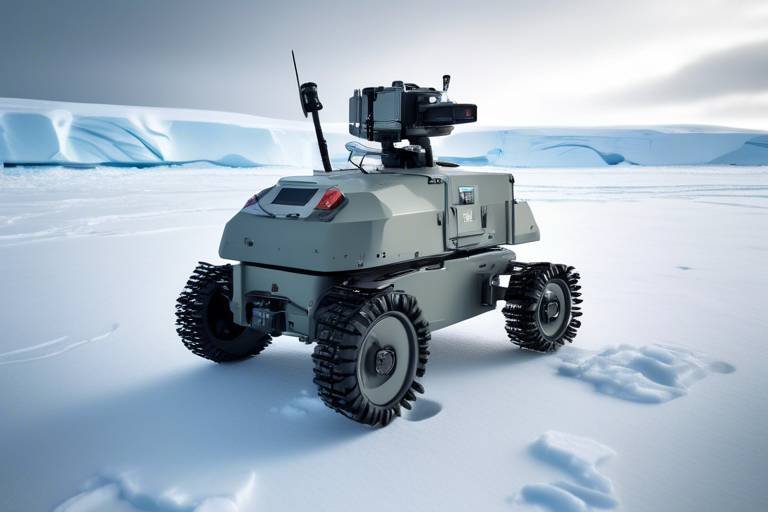
Ground-Based Robotics
Ground-based robotics is revolutionizing the way we monitor urban environments. Unlike their aerial counterparts, these robots operate at ground level, providing unique advantages that are particularly useful in densely populated cities. They can navigate through narrow alleys, parks, and even indoor spaces, collecting data from areas that are often difficult for humans to access. Imagine a robot gliding smoothly along a sidewalk, equipped with sensors that can detect air pollutants, temperature variations, and even noise levels. This capability not only enhances data collection but also allows for a more comprehensive understanding of environmental conditions in urban settings.
One of the standout features of ground-based robotics is their ability to operate autonomously or semi-autonomously. This means they can perform monitoring tasks without constant human oversight, making them incredibly efficient. For instance, a ground robot can traverse a park multiple times a day, collecting data on soil moisture and vegetation health. This continuous monitoring helps city planners and environmental scientists make informed decisions about resource allocation and urban development. Furthermore, these robots can be equipped with advanced technologies such as GPS, LiDAR, and various sensors, which enable them to map their surroundings and gather precise data.
Additionally, ground-based robots are particularly adept at real-time monitoring. They can send data back to a central system instantly, allowing for immediate analysis and response. This is crucial in urban environments where conditions can change rapidly due to human activities or natural events. For example, if a ground robot detects a spike in pollution levels in a specific area, city officials can be alerted immediately, allowing them to take action before the situation worsens. This capability not only enhances the effectiveness of environmental monitoring but also contributes to better public health outcomes.
However, it’s important to acknowledge that ground-based robotics also faces challenges. The urban landscape is filled with obstacles such as pedestrians, vehicles, and unpredictable weather conditions. These factors can hinder the robots' ability to navigate and collect data effectively. To mitigate these challenges, developers are continually improving navigation algorithms and incorporating machine learning technologies that enable robots to adapt to their environments. As these technologies evolve, we can expect ground-based robots to become even more reliable and efficient in their monitoring tasks.
In summary, ground-based robotics plays a pivotal role in urban environmental monitoring. Their capacity to access hard-to-reach areas, operate autonomously, and provide real-time data makes them invaluable tools for understanding and managing urban ecosystems. As cities continue to grow and face environmental challenges, the integration of these robotic systems will be essential for fostering sustainable urban development and ensuring a healthier environment for all city dwellers.
Benefits of Robotic Monitoring
Robotic monitoring is not just a futuristic concept; it's a reality that's reshaping how we understand and manage our urban environments. The integration of robotics in environmental monitoring brings a plethora of benefits that can significantly enhance urban sustainability efforts. Imagine having a team of robots tirelessly collecting data, analyzing air quality, and monitoring vegetation health while humans focus on strategic decision-making. This is not just a dream—it's happening now!
One of the most notable advantages of robotic monitoring is the increased efficiency it offers. Traditional monitoring methods often require extensive manpower and time, which can lead to delays in data collection and analysis. With robots, data can be gathered quickly and efficiently, allowing for more timely interventions in environmental management. For instance, drones can cover vast areas in a fraction of the time it would take a human team, enabling cities to respond to environmental issues almost in real-time.
Moreover, the accuracy of data collected by robots is another significant benefit. Human error is an inevitable factor in manual data collection, but robotic systems can gather data with remarkable precision. This enhanced accuracy not only improves the quality of environmental assessments but also aids in making informed decisions. For example, when monitoring air quality, even slight variations can have substantial implications for public health. Robots equipped with advanced sensors can detect these changes more reliably than traditional methods.
Additionally, robotic monitoring systems can operate in hazardous environments that may be unsafe for human workers. Whether it's assessing pollution levels in a contaminated area or monitoring a flood-prone zone, robots can gather crucial data without putting lives at risk. This capability opens up new avenues for environmental monitoring, allowing for comprehensive assessments in areas that were previously deemed too dangerous for human intervention.
Furthermore, the ability to conduct real-time monitoring is a game-changer for urban planners and environmental scientists. Robotics technology enables continuous data collection, providing a constant stream of information that can be analyzed and acted upon immediately. For instance, if a sudden spike in air pollution levels is detected, city officials can be alerted right away, allowing them to implement emergency measures to protect public health. This dynamic response capability is something traditional monitoring methods simply cannot match.
In summary, the benefits of robotic monitoring extend far beyond mere data collection. They pave the way for a more sustainable and responsive approach to urban environmental management. As cities continue to grow and face new environmental challenges, the role of robotics in monitoring will only become more critical. By harnessing the power of technology, urban areas can not only enhance their monitoring capabilities but also improve the quality of life for their residents.
- What types of robots are used in environmental monitoring?
Both drones and ground-based robots are commonly used for environmental monitoring. Drones are particularly effective for aerial surveillance, while ground-based robots can access hard-to-reach areas.
- How does robotic monitoring improve data accuracy?
Robots are equipped with advanced sensors that collect data with high precision, minimizing the potential for human error in the data collection process.
- Can robotic monitoring be used in hazardous environments?
Yes, one of the significant advantages of robotic monitoring is its ability to operate in hazardous conditions, ensuring that data is collected without putting human lives at risk.
- What is the future of robotics in urban environmental monitoring?
The future looks promising, with advancements in AI and machine learning expected to enhance the capabilities of robotic monitoring systems even further.
Enhancing Data Accuracy
In the realm of urban environmental monitoring, the quest for data accuracy is paramount. Traditional methods often rely on manual data collection, which can be prone to human error and inconsistencies. However, with the advent of robotics, we are witnessing a significant transformation in how data is gathered and analyzed. Robots, equipped with advanced sensors and algorithms, can collect data with remarkable precision, which not only enhances the reliability of the information but also facilitates better decision-making processes.
One of the key advantages of robotic monitoring is the ability to operate in hard-to-reach areas where human presence may be limited or dangerous. For instance, consider a scenario where environmental assessments need to be conducted in hazardous zones, such as near industrial sites or areas affected by natural disasters. Here, ground-based robots can navigate through challenging terrains, collecting data that would otherwise be inaccessible. This capability not only broadens the scope of data collection but also ensures that the information is comprehensive and reflective of the actual environmental conditions.
Moreover, the integration of machine learning and artificial intelligence in robotic systems enhances their data processing capabilities. These technologies allow robots to analyze vast amounts of data in real-time, identifying patterns and anomalies that might be missed by human observers. For instance, drones equipped with AI can analyze air quality data and detect pollution sources instantly, enabling swift interventions. This level of accuracy is crucial, especially in urban settings where environmental changes can occur rapidly and have significant impacts on public health.
To illustrate the impact of enhanced data accuracy through robotics, let's consider a comparison of traditional monitoring methods versus robotic monitoring:
| Aspect | Traditional Monitoring | Robotic Monitoring |
|---|---|---|
| Data Collection Speed | Slow, manual collection | Fast, automated collection |
| Human Error | High potential for errors | Minimal errors due to automation |
| Accessibility | Limited to safe areas | Can access hazardous or remote locations |
| Data Analysis | Delayed, manual processing | Real-time analysis with AI |
As we can see from the table, the advantages of robotic monitoring are clear and compelling. The enhanced accuracy achieved through robotics not only improves the quality of data collected but also empowers urban planners and environmental scientists to make informed decisions. With precise data, cities can implement effective strategies to combat pollution, manage resources, and promote sustainability.
In conclusion, as we continue to embrace robotics in environmental monitoring, we can expect a significant shift towards more accurate, efficient, and comprehensive data collection methodologies. This evolution will undoubtedly play a crucial role in shaping the future of urban sustainability and resilience.
- How do robots enhance data accuracy in environmental monitoring?
Robots use advanced sensors and AI algorithms to collect and analyze data with high precision, reducing human error and improving the reliability of information. - Can robots access hazardous areas for monitoring?
Yes, ground-based robots can navigate challenging terrains and hazardous environments, allowing for comprehensive data collection in places that are unsafe for humans. - What role does AI play in robotic monitoring?
AI enables robots to process large datasets in real-time, identifying patterns and anomalies that enhance decision-making and timely interventions.
Real-Time Monitoring Capabilities
In the fast-paced world we live in, the ability to monitor environmental changes in real-time is not just a luxury; it’s a necessity. Imagine being able to detect a rise in air pollution levels or a sudden change in temperature within minutes rather than days. This is where robotics shines, transforming our approach to urban environmental monitoring. With the integration of advanced sensors and data analytics, robots can deliver immediate insights that are crucial for effective decision-making.
One of the most significant advantages of robotic monitoring is the capacity for immediate data analysis. For instance, drones equipped with air quality sensors can fly over urban areas, collecting data on pollutants like nitrogen dioxide and particulate matter. As they gather this information, it is processed in real-time, allowing city planners and environmental agencies to respond swiftly to potential health hazards. This immediacy is essential, especially in densely populated cities where air quality can change rapidly.
Moreover, ground-based robots contribute significantly to real-time monitoring by traversing challenging terrains that may be inaccessible to humans. These robots can navigate through parks, alleyways, and even underground systems to collect data on soil moisture levels, temperature fluctuations, and biodiversity. By deploying these robots, cities can gain a comprehensive understanding of their environmental conditions without putting human operators at risk.
However, the real-time capabilities of robotic monitoring systems are not solely dependent on the robots themselves. They also rely on a robust communication infrastructure. Data collected by these robots must be transmitted to centralized databases or cloud platforms where it can be analyzed and visualized. This interplay between hardware and software is vital, as it ensures that the data is not only collected but also made accessible for stakeholders who need it.
To illustrate the impact of real-time monitoring, consider the following table that showcases various applications and their benefits:
| Application | Type of Robot | Real-Time Benefit |
|---|---|---|
| Air Quality Monitoring | Drones | Immediate alerts for pollution spikes |
| Flood Detection | Ground Robots | Quick assessment of water levels |
| Biodiversity Tracking | Ground Robots | Instant data on species presence |
As cities continue to expand and environmental challenges grow more complex, the ability to monitor changes in real-time will become increasingly critical. Robotics not only enhances our capacity to gather and analyze data but also empowers us to make informed decisions that can lead to sustainable urban development. With these technologies at our disposal, we can proactively address environmental issues before they escalate, ensuring a healthier and more sustainable future for urban populations.
- How do drones improve air quality monitoring? Drones can cover large areas quickly and provide real-time data on air pollutants, allowing for immediate responses to air quality issues.
- What are the limitations of ground-based robots? Ground robots may face challenges in navigating certain terrains and require a stable power source for extended operations.
- How is the data collected by robots analyzed? The data is transmitted to cloud platforms where it undergoes analysis using advanced algorithms to provide actionable insights.
Future Trends in Robotics and Monitoring
As we gaze into the crystal ball of technology, it’s clear that the future of robotics in urban environmental monitoring is set to be nothing short of revolutionary. With the rapid advancements in artificial intelligence (AI) and machine learning, we are on the brink of a new era where data collection and analysis will become more sophisticated, efficient, and accurate than ever before. Imagine a world where robots not only gather data but also analyze it in real-time, providing actionable insights at the touch of a button. This is not just a dream; it’s becoming a reality.
One of the most exciting trends is the integration of AI algorithms with robotic systems. These algorithms will enable robots to learn from the data they collect, improving their performance over time. For instance, a drone monitoring air quality could adjust its flight patterns based on previous data, optimizing its routes to cover areas with the most significant pollution levels. This kind of adaptability will enhance the effectiveness of urban environmental monitoring, making it more responsive to changing conditions.
Furthermore, the advent of swarm robotics is another trend that promises to transform monitoring efforts. Just as a flock of birds moves in unison, swarm robotics involves multiple robots working together to collect data. This approach can cover larger areas more efficiently than a single robot could. For example, a swarm of drones could simultaneously monitor different parts of a city, providing a comprehensive overview of environmental conditions in real-time. The synergy of these robots will lead to a more thorough understanding of urban ecosystems.
Additionally, the integration of Internet of Things (IoT) technology with robotics will further enhance monitoring capabilities. IoT devices can collect vast amounts of data from various sources, such as sensors embedded in the environment. When combined with robotic systems, this data can be analyzed to identify trends and patterns that might otherwise go unnoticed. For example, smart sensors can detect changes in soil moisture levels, which robots can then monitor and report on, helping urban planners make informed decisions about water management and conservation.
However, with these advancements come challenges that must be addressed. Issues related to data privacy and security are paramount, as the collection of sensitive environmental data could lead to misuse if not properly safeguarded. Moreover, regulatory frameworks will need to evolve to keep pace with technological advancements, ensuring that the deployment of robotic systems in urban environments is safe and effective.
In summary, the future of robotics in urban environmental monitoring is bright and filled with potential. With AI, swarm robotics, and IoT technologies leading the charge, we can expect a significant transformation in how we gather and analyze environmental data. Cities will become smarter, more sustainable, and better equipped to tackle the challenges posed by urbanization and climate change. The question remains: are we ready to embrace this technological revolution and harness its capabilities for a healthier planet?
- What are the main benefits of using robotics for environmental monitoring?
Robotics enhances data collection efficiency, accuracy, and the ability to operate in hazardous environments, leading to better urban planning and sustainability efforts. - How do drones improve urban environmental monitoring?
Drones provide real-time aerial surveillance, allowing for extensive data collection on air quality, vegetation health, and more, covering large areas quickly. - What challenges do drones face in urban monitoring?
Challenges include regulatory restrictions, technical limitations, and privacy concerns, which need to be addressed for effective implementation. - What role does AI play in the future of robotics for monitoring?
AI enables robots to analyze data in real-time and learn from previous data, improving their monitoring capabilities and adaptability.
Frequently Asked Questions
- What is urban environmental monitoring?
Urban environmental monitoring refers to the systematic collection and analysis of data regarding the environmental conditions in urban areas. This monitoring is crucial for understanding how human activities impact ecosystems, air quality, and overall urban health.
- How do robots enhance environmental monitoring?
Robots improve environmental monitoring by providing accurate and efficient data collection. With technologies like drones and ground-based robots, they can access hard-to-reach areas and gather extensive data quickly, which enhances the quality of environmental assessments.
- What types of robots are used in urban monitoring?
There are mainly two types of robots used in urban environmental monitoring: drones for aerial surveillance and ground-based robots for on-the-ground data collection. Each type has its own set of applications and benefits in monitoring urban environments.
- What advantages do drones offer for environmental monitoring?
Drones provide real-time data on various environmental factors such as air quality and vegetation health. They cover large areas quickly, making them ideal for monitoring urban heat islands and other environmental challenges.
- What challenges do drones face in environmental monitoring?
Despite their advantages, drones encounter challenges like regulatory restrictions and technical limitations. These issues can hinder their effectiveness, but ongoing advancements and regulatory adjustments aim to address these obstacles.
- How do ground-based robots contribute to monitoring?
Ground-based robots play a crucial role in collecting data from areas that might be difficult for humans to access. They are particularly useful for real-time monitoring and can operate in hazardous environments where human presence may be risky.
- What are the benefits of robotic monitoring?
Robotic monitoring offers several benefits, including increased efficiency and accuracy in data collection. This technology allows for monitoring in hazardous conditions and provides timely data that can inform urban planning and environmental policies.
- How does robotics improve data accuracy?
Robots are designed to collect data with high precision, significantly reducing the potential for human error. This improved accuracy enhances the reliability of environmental assessments and supports better decision-making processes.
- What is the significance of real-time monitoring?
Real-time monitoring is vital as it enables immediate analysis and response to environmental changes. This capability is essential for timely interventions that can mitigate potential environmental issues in urban settings.
- What does the future hold for robotics in urban monitoring?
The future of robotics in urban environmental monitoring looks promising, with advancements in artificial intelligence and machine learning. These technologies are expected to further enhance monitoring capabilities, making data collection even more efficient and insightful.