How Satellites Support Urban Warfare Tactics
In today's fast-paced world, urban warfare has become a complex battleground where traditional tactics often fall short. The integration of satellite technology has revolutionized how military operations are conducted in these densely populated environments. Imagine a chess game where each piece is constantly moving and hiding behind obstacles; this is the reality of urban combat, and satellites act as the eyes in the sky, providing crucial insights and support. They play a pivotal role in reconnaissance, communication, and strategic planning, enabling military forces to adapt and respond effectively in ever-changing scenarios.
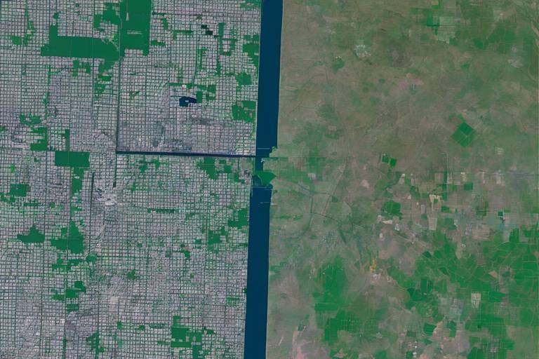
One of the most significant advantages of using satellites in urban warfare is their ability to provide real-time imagery and intelligence. This capability allows military forces to assess urban landscapes with remarkable accuracy. Think of it as having a bird's-eye view of a sprawling city, where every alley and rooftop can be analyzed for enemy positions and potential threats. By utilizing advanced imaging technologies, satellites can capture detailed visuals that inform military planners about the layout of urban areas, helping them devise effective strategies. For instance, during an operation, commanders can identify key infrastructure and potential hiding spots for enemy combatants, allowing for more targeted and efficient missions.
In the chaos of urban warfare, communication is vital. Satellites facilitate secure communication channels for military units, ensuring that coordination and command remain intact even when traditional communication methods falter. Urban environments often present a myriad of challenges—high buildings, dense structures, and electronic interference can disrupt ground-based communications. However, with satellite technology, troops can maintain a reliable line of communication, enabling them to share critical information swiftly and effectively.
High-speed data transmission via satellites is another game-changer in urban combat scenarios. Imagine being able to send and receive crucial updates in real-time, enhancing situational awareness among troops. This instant sharing of information can mean the difference between success and failure during engagements. Whether it’s relaying enemy movements, coordinating air support, or adjusting tactical plans, satellites ensure that every unit is on the same page, ready to act when needed.
Despite the potential obstructions in urban settings, the reliability of satellite signals remains crucial. Urban warfare is often fast-paced, and maintaining communication continuity is essential for effective operations. With satellites, even in the most challenging environments, troops can rely on consistent signals that keep them connected, ensuring that command can issue orders and receive feedback without delay.
In emergencies, satellite communication systems become lifelines for troops and support personnel. Imagine being in a situation where ground-based networks have failed, and the only way to call for help is through satellite links. These systems ensure that military personnel remain connected, allowing for timely assistance and coordination during critical moments.
Another vital aspect of satellite support in urban warfare is navigation. Urban terrains can be incredibly complex, with winding streets and high-rise buildings that can easily confuse even the most seasoned soldiers. Satellite navigation systems help military forces navigate these challenging environments, guiding them to their objectives accurately. This capability is akin to having a GPS that not only shows the route but also provides real-time updates on enemy positions and potential hazards, enhancing the overall effectiveness of military operations.
Satellites significantly enhance intelligence-gathering capabilities, allowing for comprehensive monitoring of enemy movements and activities. The ability to gather actionable intelligence gives military planners a strategic advantage in urban warfare scenarios. By continuously observing urban areas, satellites can detect potential threats and provide invaluable insights that inform decision-making.
Advanced surveillance capabilities of satellites enable continuous monitoring, ensuring that military forces are always a step ahead. This constant vigilance allows commanders to anticipate enemy actions and adjust their strategies accordingly. In a game of chess, knowing your opponent's next move can provide a significant edge; similarly, satellite surveillance offers a tactical advantage in urban combat.
The analysis of satellite data can reveal patterns in enemy behavior, helping commanders make informed decisions during urban combat operations. By identifying trends and movements, military leaders can develop strategies that capitalize on enemy weaknesses, ultimately leading to more successful outcomes in the field.
The integration of satellite technology into tactical planning has transformed how military operations are conducted in urban settings. It influences strategies and outcomes, allowing for more dynamic and responsive approaches to combat. With real-time data from satellites, commanders can make adjustments on-the-fly, adapting to changing conditions on the ground.
Imagine being in a fast-paced video game where the landscape shifts with every move; this is similar to the fluid nature of urban warfare. With satellite support, commanders can react swiftly to new information, adjusting their strategies to maximize effectiveness. This adaptability is crucial in urban combat, where the situation can change in an instant.
Finally, satellite insights assist in effective resource allocation. In urban conflict zones, ensuring that troops are deployed efficiently and that logistical support reaches the right locations is critical. Satellites help military planners visualize the battlefield, making it easier to allocate resources where they are most needed.
- How do satellites enhance communication in urban warfare? Satellites provide secure communication channels that remain reliable even when traditional methods fail, ensuring troops can coordinate effectively.
- What role do satellites play in reconnaissance? Satellites offer real-time imagery and intelligence, allowing military forces to assess urban landscapes and identify enemy positions.
- Can satellites help in emergency situations? Yes, satellite communication systems act as lifelines, providing connectivity when ground-based networks are compromised.
Satellite Reconnaissance
In the ever-evolving landscape of modern warfare, has emerged as a game-changer, particularly in urban settings where every corner can hide a potential threat. Imagine being able to survey an entire city from above, pinpointing enemy positions and assessing the terrain without ever setting foot on the ground. This capability is not just a luxury; it's a necessity for military forces operating in densely populated environments. With the ability to provide real-time imagery and intelligence, satellites empower commanders to make informed decisions that can mean the difference between success and failure in the heat of battle.
One of the most significant advantages of satellite reconnaissance is its ability to deliver high-resolution images that reveal intricate details of urban landscapes. These images can show everything from troop movements to the layout of buildings, enabling military planners to devise effective strategies tailored to the unique challenges of urban warfare. For instance, a satellite can capture images that highlight not only enemy positions but also civilian infrastructure, which is crucial for minimizing collateral damage and ensuring the safety of non-combatants.
Moreover, the integration of advanced imaging technology allows for the analysis of various data layers, providing a comprehensive view of the battlefield. This includes:
- Infrared Imaging: Helps in detecting heat signatures, revealing hidden enemy units.
- Multi-Spectral Imaging: Assists in identifying materials and structures, crucial for planning demolitions or airstrikes.
- 3D Terrain Mapping: Offers a three-dimensional perspective of the urban environment, aiding in navigation and tactical movement.
These capabilities not only enhance situational awareness but also facilitate rapid response to emerging threats. By analyzing the data collected from satellites, military leaders can anticipate enemy actions and adjust their tactics accordingly. This kind of foresight is invaluable in urban warfare, where the fast-paced nature of combat can lead to chaotic scenarios.
Furthermore, satellite reconnaissance plays a pivotal role in intelligence gathering. The continuous monitoring of urban areas allows for the detection of unusual activities that may indicate hostile intentions. By establishing a pattern of life for enemy forces, commanders can identify potential vulnerabilities and exploit them to their advantage. This proactive approach to intelligence not only aids in immediate operations but also contributes to long-term strategic planning.
In summary, satellite reconnaissance serves as the eyes in the sky, providing military forces with a comprehensive understanding of the urban battlefield. The ability to gather and analyze data in real-time transforms how operations are conducted, ensuring that forces are better prepared and more adaptive to the complexities of urban warfare.
Communication Networks
In the realm of urban warfare, where chaos reigns and every second counts, become the lifeblood of military operations. Imagine trying to navigate a bustling cityscape filled with towering buildings, narrow alleys, and the constant threat of enemy ambushes. In such an environment, the ability to communicate securely and effectively can mean the difference between success and failure. Satellites play a pivotal role in establishing these communication networks, providing a reliable backbone that can withstand the challenges posed by urban combat.
One of the most significant advantages of satellite communication is its ability to create secure channels for military units. In densely populated areas, traditional communication methods, like radio transmissions, can be easily intercepted or jammed by adversaries. However, satellite systems offer a level of encryption and security that makes it much harder for enemies to eavesdrop. This ensures that commanders can relay orders and receive updates without the fear of their plans being compromised. Moreover, the global reach of satellite communication means that military forces can maintain contact with command centers, even when deployed in the most remote or hostile urban environments.
Another critical aspect of satellite communication is data transmission. With the advent of high-speed satellite technology, military units can share information almost instantaneously. Imagine a unit on the ground spotting an enemy position. With just a few clicks, they can transmit real-time video feeds and reconnaissance data back to their command center. This rapid sharing of information enhances situational awareness, allowing commanders to make informed decisions quickly. In urban warfare, where the landscape can change in an instant, having access to real-time data can significantly improve response times and operational effectiveness.
Despite the advantages, urban environments can pose unique challenges for satellite communication. Tall buildings and other structures can obstruct signals, leading to potential communication blackouts. However, advancements in satellite technology have improved signal reliability, ensuring that military units can maintain communication even in the most challenging urban terrains. Modern satellites are equipped with sophisticated tracking systems that can adjust their signals to overcome obstructions, providing a consistent flow of information.
In times of crisis, when ground-based communication networks fail—whether due to enemy interference or infrastructure damage—satellite communication systems act as a vital lifeline for troops and support personnel. These systems ensure that emergency calls for backup, medical assistance, or logistical support can still be made. Imagine a squad pinned down in a firefight, unable to reach their base. With satellite communication, they can send a distress signal that reaches their command center, prompting an immediate response. This capability not only saves lives but also enhances the overall effectiveness of military operations in urban settings.
In summary, the role of satellites in establishing robust communication networks during urban warfare is indispensable. They provide secure channels, enable high-speed data transmission, ensure signal reliability, and serve as crucial emergency communication tools. As urban combat continues to evolve, the reliance on satellite technology will only grow, shaping the future of military operations in complex environments.
- How do satellites improve communication in urban warfare?
Satellites provide secure communication channels that are less susceptible to interception and jamming, allowing military units to communicate effectively even in chaotic environments.
- What challenges do satellites face in urban areas?
Tall buildings and other obstructions can disrupt signals, but advancements in technology have improved signal reliability, allowing for continuous communication.
- Can satellite communication be used in emergencies?
Yes, satellite communication systems are crucial during emergencies as they provide a reliable means to call for help when ground-based networks are compromised.
Data Transmission
In the high-stakes world of urban warfare, plays a pivotal role in ensuring military operations are both effective and efficient. Imagine being in a densely populated city where every corner could hide a potential threat. In such scenarios, the ability to transmit information instantly can mean the difference between success and failure. Satellites provide this critical capability by enabling high-speed data transmission that allows for real-time sharing of vital intelligence among troops. This means that soldiers on the ground can receive up-to-the-minute updates about enemy movements, changes in terrain, and emerging threats, all of which enhance their situational awareness.
Furthermore, the integration of satellite technology into military operations has revolutionized how data is shared. Traditional communication methods, such as radios or ground-based networks, often fall short in urban environments where buildings and other structures can obstruct signals. However, satellites orbiting high above can circumvent these obstacles, ensuring that communication remains uninterrupted. For instance, during an operation in a crowded urban area, a squad can relay their position and status to command centers without the fear of losing connectivity. This reliability is crucial, especially when troops are engaged in fast-paced combat situations where every second counts.
Moreover, the types of data transmitted via satellites are diverse and can include video feeds, geospatial information, and even sensor data. This multifaceted approach allows military planners to have a comprehensive understanding of the battlefield. For example, a satellite might relay video footage of an enemy stronghold while simultaneously providing GPS coordinates, enabling precision strikes or tactical maneuvers. This kind of synchronized data flow is not just beneficial; it is a game-changer in urban warfare.
To further illustrate the impact of satellite data transmission, consider the following table that highlights the key advantages:
| Advantage | Description |
|---|---|
| Real-Time Updates | Instant access to critical information enhances decision-making and operational effectiveness. |
| Signal Reliability | Satellites provide consistent communication even in challenging urban environments. |
| Diverse Data Types | Multiple forms of data can be transmitted, including imagery, location data, and sensor readings. |
| Enhanced Coordination | Improves synchronization among various military units, leading to more effective operations. |
In conclusion, the role of data transmission via satellites cannot be overstated. It not only enhances the operational capabilities of military forces but also ensures that they remain agile and responsive in the face of rapidly changing conditions on the ground. As urban warfare continues to evolve, the reliance on such technology will only increase, making it a cornerstone of modern military strategy.
- How do satellites improve communication in urban warfare? Satellites provide reliable communication channels that can bypass obstacles found in urban environments, ensuring troops stay connected.
- What types of data can satellites transmit? Satellites can transmit a variety of data, including video feeds, geospatial information, and sensor data, which are crucial for operational success.
- Why is real-time data important in combat? Real-time data allows military commanders to make informed decisions quickly, adapting strategies to the changing dynamics of the battlefield.
Signal Reliability
This article explores the critical role of satellites in modern urban warfare, examining their impact on reconnaissance, communication, and strategic planning in densely populated environments.
Satellite reconnaissance provides real-time imagery and intelligence, enabling military forces to assess urban landscapes, identify enemy positions, and plan operations effectively.
Satellites facilitate secure communication channels for military units, ensuring coordination and command in complex urban environments where traditional communication may be compromised.
High-speed data transmission via satellites allows for instant sharing of critical information among troops, enhancing situational awareness and response times during urban engagements.
The reliability of satellite signals in urban areas is a game-changer, especially when you consider the myriad of obstacles that can interfere with communication. Urban landscapes are often filled with towering buildings, dense foliage, and other structures that can obstruct signals. However, modern satellite technology has evolved to mitigate these challenges. For instance, satellites equipped with advanced signal processing capabilities can adapt to changing environments, ensuring that communication remains stable and effective even in the most chaotic situations.
When we think about the importance of signal reliability, it’s crucial to recognize that, in the heat of battle, every second counts. Troops need to communicate swiftly and clearly, and any disruption can lead to confusion and potentially catastrophic outcomes. This is where satellite technology shines, providing a robust backbone for communication that can withstand the pressures of urban warfare. The ability to maintain clear lines of communication allows commanders to relay orders, share intelligence, and coordinate movements seamlessly, which is vital for mission success.
Furthermore, satellite signals can be bolstered through various methods, such as:
- Signal Repeaters: These devices can amplify satellite signals, ensuring they reach troops in hard-to-access areas.
- Adaptive Bandwidth= By dynamically adjusting the bandwidth used for communication, satellites can maintain connections even when signal strength fluctuates.
- Multi-frequency Communication: Utilizing multiple frequencies can help bypass obstructions and enhance overall signal reliability.
In essence, the reliability of satellite communication systems not only enhances operational efficiency but also serves as a lifeline for troops operating in hostile urban environments.
In emergencies, satellite communication systems can provide lifelines for troops and support personnel, ensuring they remain connected even when ground-based networks fail.
Satellite navigation systems play a vital role in guiding military operations through urban terrains, helping forces navigate and position themselves accurately amidst complex environments.
Satellites enhance intelligence-gathering capabilities by monitoring enemy movements and activities, providing a strategic advantage in urban warfare scenarios.
Advanced surveillance capabilities of satellites allow for continuous monitoring of urban areas, detecting potential threats and gathering actionable intelligence for military planners.
The analysis of satellite data can reveal patterns in enemy behavior, aiding commanders in making informed decisions during urban combat operations.
The integration of satellite technology into tactical planning transforms how military operations are conducted in urban settings, influencing strategies and outcomes.
With real-time data from satellites, commanders can adjust strategies on-the-fly, responding swiftly to changing conditions on the ground in urban warfare.
Satellite insights assist in effective resource allocation, ensuring that troops are deployed efficiently and that logistical support reaches the right locations in urban conflict zones.
- How do satellites improve communication in urban warfare?
Satellites provide reliable communication channels that can operate despite urban obstructions, ensuring troops stay connected during operations.
- What role does satellite navigation play in urban combat?
Satellite navigation systems help military forces accurately navigate complex urban terrains, which is essential for successful operations.
- Can satellite signals be disrupted in urban areas?
While urban environments pose challenges to satellite signals, advanced technology helps mitigate these issues, ensuring reliable communication.
Emergency Communication
In the chaotic environment of urban warfare, where the stakes are high and the situation can change in an instant, emerges as a lifeline for military personnel. Imagine being in a densely populated city, with buildings towering over you, and the sounds of conflict echoing all around. In such scenarios, traditional communication methods can often fail due to damaged infrastructure or overwhelming electronic interference. This is where satellites step in, providing a vital communication backbone that keeps troops connected, informed, and operational.
One of the most significant advantages of satellite communication systems is their ability to function independently of ground-based networks. These systems can transmit data, voice, and video signals from anywhere in the world, ensuring that commanders can reach their troops even in the most challenging conditions. For instance, during an emergency, if a unit is surrounded and needs immediate support, satellite communication enables them to send distress signals and receive instructions without delay. This capability can be the difference between life and death on the battlefield.
Moreover, satellite communication systems are designed to be robust and reliable. They can withstand various environmental factors, including harsh weather conditions and potential obstructions like tall buildings. This reliability is crucial for maintaining continuous communication during fast-paced combat situations. Troops can share real-time updates, coordinate movements, and request reinforcements, all while remaining connected to their command centers.
To illustrate the importance of emergency communication, consider the following table that outlines the key benefits of satellite communication in urban warfare:
| Benefit | Description |
|---|---|
| Independence | Operates without reliance on ground infrastructure, ensuring connectivity even when local networks are down. |
| Real-time Updates | Facilitates instant sharing of critical information, enhancing situational awareness for all units involved. |
| Robustness | Designed to withstand adverse conditions, maintaining communication integrity during urban combat. |
| Coordination | Allows for efficient coordination among various units, improving tactical responses to emergencies. |
In summary, emergency communication via satellite systems is not just a convenience; it's a necessity in urban warfare. It empowers military forces to act swiftly and decisively, ensuring that they can maintain command and control even in the most unpredictable situations. The ability to communicate effectively can turn the tide of battle, enabling troops to adapt, respond, and survive in the dynamic landscape of urban conflict.
- How do satellites improve communication in urban warfare?
Satellites provide reliable communication channels that are independent of ground-based networks, ensuring troops can stay connected even when traditional methods fail. - What are the advantages of using satellite communication in emergencies?
Satellite communication allows for real-time updates, robust connectivity, and efficient coordination among military units, which is crucial during emergencies. - Can satellite communication work in adverse weather conditions?
Yes, satellite communication systems are designed to withstand various environmental factors, ensuring reliable performance even in harsh weather.
Satellite Navigation
In the chaotic theater of urban warfare, where every street corner can hide an enemy and every building can serve as a vantage point, emerges as a crucial ally for military forces. Imagine trying to navigate a dense city with narrow alleys and towering skyscrapers without a reliable guide. This is precisely where satellite navigation systems come into play, providing troops with the ability to pinpoint their locations with incredible accuracy. These systems utilize a network of satellites that orbit the Earth, sending signals to ground-based receivers. This allows soldiers to receive real-time data about their positioning, ensuring they can maneuver effectively through complex urban environments.
Moreover, the importance of satellite navigation extends beyond mere location tracking. It enables forces to coordinate movements efficiently, ensuring that units can converge on targets or retreat safely when necessary. With the help of satellite navigation, commanders can plot routes that minimize exposure to enemy fire while maximizing operational effectiveness. For instance, when a unit needs to move from one side of a city to another, satellite navigation can provide the safest and quickest paths, avoiding known hotspots of enemy activity.
Additionally, satellite navigation systems are equipped with advanced features that enhance their functionality in urban warfare. These features include:
- Terrain Mapping: The ability to overlay satellite imagery with maps helps soldiers understand the landscape and identify potential obstacles.
- Geofencing: This technology allows commanders to set virtual boundaries, alerting them if troops stray into dangerous areas.
- Integration with Other Systems: Satellite navigation can be integrated with drones and reconnaissance vehicles, providing a comprehensive view of the battlefield.
In essence, satellite navigation is not just about getting from point A to point B; it’s about enhancing the overall effectiveness of military operations. The real-time data provided by these systems can be the difference between success and failure in urban combat scenarios. As cities become increasingly complex battlegrounds, the reliance on precise navigation technologies will only grow, allowing military forces to adapt and thrive in environments that are both challenging and unpredictable.
1. How accurate is satellite navigation in urban environments?
Satellite navigation systems are generally very accurate, often within a few meters. However, in urban areas, tall buildings can sometimes interfere with signals, which may slightly reduce accuracy. Despite this, advancements in technology continue to improve reliability.
2. Can satellite navigation systems be used in areas without GPS coverage?
Yes, while GPS is the most common satellite navigation system, there are alternatives like GLONASS, Galileo, and BeiDou, which can be used to provide navigation services even in areas where one system may be less effective.
3. How do military forces ensure satellite navigation systems are secure?
Military forces employ various encryption and anti-jamming technologies to secure satellite navigation systems, ensuring that they remain operational and reliable even in contested environments.
Intelligence Gathering
In the realm of modern warfare, has become a cornerstone of operational success, especially in urban environments where chaos reigns. Satellites play an indispensable role in this process, offering a bird's-eye view that is simply unattainable through conventional means. Imagine trying to navigate a bustling city without a map—this is what military forces would face without satellite support. By utilizing advanced imaging technology, satellites provide crucial insights that enable military planners to monitor enemy movements, assess potential threats, and strategize effectively.
One of the most remarkable features of satellite intelligence gathering is its ability to deliver continuous surveillance. Unlike traditional reconnaissance methods, which may rely on ground units or aerial assets that can be easily compromised, satellites orbiting high above the Earth can maintain a watchful eye over urban landscapes at all times. This capability is particularly vital in densely populated areas where the risk of collateral damage is high. By providing real-time data, satellites allow military forces to make informed decisions that minimize civilian casualties while achieving strategic objectives.
Furthermore, the analysis of satellite data can reveal intricate patterns in enemy behavior. For instance, military analysts can identify routine movements, supply routes, and even potential hideouts. This information is akin to piecing together a jigsaw puzzle—each piece contributes to a clearer picture of the battlefield. By understanding how the enemy operates, commanders can develop tailored strategies that exploit weaknesses and capitalize on opportunities.
To illustrate the impact of satellite technology on intelligence gathering, consider the following table that outlines key benefits:
| Benefit | Description |
|---|---|
| Real-time Monitoring | Continuous observation of enemy movements and activities. |
| Pattern Recognition | Identifying trends in behavior for informed decision-making. |
| Minimized Risk | Reducing the need for ground reconnaissance in hostile areas. |
| Enhanced Coordination | Improving communication between units based on accurate intelligence. |
In addition to these benefits, the integration of satellite intelligence into military operations fosters a proactive approach to urban warfare. Instead of merely reacting to enemy actions, military commanders can anticipate moves and prepare counter-strategies. This shift from a reactive to a proactive mindset can be the difference between success and failure in the high-stakes environment of urban combat.
In conclusion, the role of satellites in intelligence gathering cannot be overstated. They provide the vital information that shapes military strategies and influences outcomes in urban warfare, ensuring that forces are always one step ahead of their adversaries. As technology continues to advance, the capabilities of satellite reconnaissance will only grow, further enhancing the effectiveness of military operations in complex urban settings.
- How do satellites gather intelligence? Satellites use advanced imaging technology to capture real-time data and monitor enemy movements from space.
- What are the advantages of satellite intelligence in urban warfare? Satellites provide continuous surveillance, minimize risk to ground troops, and enhance decision-making through detailed analysis.
- Can satellites operate effectively in dense urban environments? Yes, despite potential obstructions, satellites can maintain reliable communication and data transmission, crucial for urban operations.
Surveillance Capabilities
In the realm of modern warfare, particularly in urban environments, the provided by satellites are nothing short of revolutionary. Imagine having a bird's-eye view of a bustling city, where every alley and rooftop can be monitored in real-time. This is the power that satellites bring to military operations, allowing forces to maintain a continuous watch over potential conflict zones. With high-resolution imagery and advanced sensor technology, satellites can capture detailed images and data that inform military strategies and enhance situational awareness.
One of the most significant advantages of satellite surveillance is its ability to operate in conditions that would be challenging for ground forces. Urban warfare often involves complex terrains, with buildings, vehicles, and civilians creating a chaotic environment. Here, satellites act as the ultimate observers, providing critical information that ground troops cannot easily access. For instance, they can identify enemy troop movements, track supply routes, and even assess the impact of previous engagements. This information is invaluable for commanders who need to make quick, informed decisions under pressure.
Moreover, satellite surveillance capabilities are not just about collecting data; they also involve sophisticated analysis. With the help of artificial intelligence and machine learning, military analysts can sift through vast amounts of satellite data to detect patterns and anomalies. This process can reveal critical insights, such as:
- Identifying frequent enemy movements in specific areas.
- Monitoring changes in infrastructure that might indicate military activity.
- Assessing civilian movements to avoid collateral damage.
As a result, the integration of satellite surveillance into military operations allows for a more nuanced understanding of the battlefield. Commanders can leverage this intelligence to devise strategies that are not only effective but also minimize risks to civilians and friendly forces. The ability to see the battlefield from above can change the course of engagements, making satellites an essential component of modern military tactics.
In conclusion, the surveillance capabilities offered by satellites enhance the effectiveness of urban warfare strategies dramatically. By providing real-time, actionable intelligence, they enable military forces to navigate the complexities of urban combat more efficiently. As technology continues to evolve, the role of satellites in warfare will likely expand, further transforming how conflicts are managed in densely populated environments.
- How do satellites gather surveillance data? Satellites utilize advanced sensors and imaging technology to capture high-resolution images and data from the Earth's surface.
- Can satellite surveillance operate in all weather conditions? While satellite surveillance is highly effective, extreme weather conditions like heavy clouds or storms can impact visibility and data quality.
- How is the data from satellites analyzed? Military analysts employ artificial intelligence and machine learning algorithms to process and interpret satellite data, revealing patterns and actionable insights.
- What is the importance of real-time data in urban warfare? Real-time data allows commanders to make swift, informed decisions, adapting strategies as the situation on the ground evolves.
Data Analysis
In the realm of urban warfare, is akin to having a tactical compass that guides military commanders through the fog of conflict. By leveraging the vast amounts of data collected from satellites, military strategists can uncover patterns in enemy movements and behaviors that would otherwise remain hidden. Imagine trying to navigate a bustling city filled with obstacles and distractions; just as a GPS helps you find the fastest route, satellite data analysis provides critical insights that can lead to victory on the battlefield.
One of the most significant advantages of satellite data analysis is its ability to process real-time information. For example, as troops engage in urban combat, satellites can continuously monitor the area and relay data back to commanders. This information can include everything from troop movements to changes in the urban landscape, such as new buildings or barricades. By analyzing this data, commanders can make informed decisions about their next moves, adapting their strategies to counter enemy tactics effectively.
Furthermore, the integration of artificial intelligence (AI) into satellite data analysis has revolutionized how military forces interpret information. AI algorithms can sift through enormous datasets, identifying trends and anomalies that a human analyst might miss. This capability allows for quicker responses to emerging threats and enhances the overall situational awareness of military operations. For instance, if a sudden increase in enemy vehicle movement is detected, AI can flag this for immediate attention, enabling commanders to adjust their tactics accordingly.
The importance of data analysis extends beyond immediate tactical advantages; it also contributes to long-term strategic planning. By analyzing historical data collected from previous engagements, military planners can identify successful tactics and strategies, as well as areas for improvement. This cyclical process of learning and adapting ensures that military forces remain one step ahead of their adversaries.
To illustrate the impact of data analysis, consider the following table, which outlines key components of satellite data analysis in urban warfare:
| Component | Description | Impact on Warfare |
|---|---|---|
| Real-time Monitoring | Continuous observation of enemy positions and movements. | Enables quick tactical adjustments to changing battlefield conditions. |
| Pattern Recognition | Identifying trends in enemy behavior over time. | Facilitates predictive analysis for future engagements. |
| AI Integration | Utilizing AI to process and analyze large data sets. | Enhances speed and accuracy of intelligence assessments. |
| Historical Data Analysis | Reviewing past engagements to inform current strategies. | Improves long-term strategic planning and operational effectiveness. |
In summary, data analysis serves as the backbone of modern military operations in urban environments. By harnessing the power of satellite technology, military forces can gain a decisive edge over their adversaries. As warfare continues to evolve, the ability to analyze and interpret data effectively will remain a crucial factor in achieving success on the battlefield.
- How do satellites collect data for military use?
Satellites collect data through various sensors, including optical, infrared, and radar technologies, which capture images and other information about the Earth's surface. - What role does AI play in data analysis?
AI enhances data analysis by quickly processing large volumes of information, identifying patterns, and providing actionable insights that support military decision-making. - Can satellite data be used in non-military contexts?
Yes, satellite data is also used in various fields, including disaster response, environmental monitoring, and urban planning.
Impact on Tactical Planning
This article explores the critical role of satellites in modern urban warfare, examining their impact on reconnaissance, communication, and strategic planning in densely populated environments.
Satellite reconnaissance provides real-time imagery and intelligence, enabling military forces to assess urban landscapes, identify enemy positions, and plan operations effectively.
Satellites facilitate secure communication channels for military units, ensuring coordination and command in complex urban environments where traditional communication may be compromised.
High-speed data transmission via satellites allows for instant sharing of critical information among troops, enhancing situational awareness and response times during urban engagements.
The reliability of satellite signals in urban areas, despite potential obstructions, is crucial for maintaining communication continuity in fast-paced combat situations.
In emergencies, satellite communication systems can provide lifelines for troops and support personnel, ensuring they remain connected even when ground-based networks fail.
Satellite navigation systems play a vital role in guiding military operations through urban terrains, helping forces navigate and position themselves accurately amidst complex environments.
Satellites enhance intelligence-gathering capabilities by monitoring enemy movements and activities, providing a strategic advantage in urban warfare scenarios.
Advanced surveillance capabilities of satellites allow for continuous monitoring of urban areas, detecting potential threats and gathering actionable intelligence for military planners.
The analysis of satellite data can reveal patterns in enemy behavior, aiding commanders in making informed decisions during urban combat operations.
The integration of satellite technology into tactical planning transforms how military operations are conducted in urban settings, influencing strategies and outcomes. Imagine a chess game where every move is informed by real-time data from above; that’s the power satellites bring to urban warfare. Commanders can leverage satellite imagery and data to visualize the battlefield, assess risks, and anticipate enemy actions. This enhanced situational awareness allows for more effective decision-making, ensuring that strategies are not just reactive but proactive.
Moreover, the ability to analyze satellite data means that military planners can identify crucial urban features—like choke points, potential ambush sites, and civilian infrastructure—that could impact operations. By understanding the urban landscape, forces can deploy troops more effectively, minimizing risk and maximizing tactical advantage. For instance, the use of 3D mapping from satellite data can reveal hidden routes and vantage points that ground forces might miss.
With real-time data from satellites, commanders can also adjust strategies on-the-fly. Imagine a scenario where a unit encounters unexpected resistance; satellite feeds can provide immediate insights into enemy troop movements, allowing for rapid reallocation of forces. This flexibility is vital in urban warfare, where conditions can change in an instant. The following table illustrates how satellite technology impacts different aspects of tactical planning:
| Aspect | Impact |
|---|---|
| Situational Awareness | Enhanced understanding of the battlefield dynamics |
| Resource Allocation | Efficient deployment of troops and equipment |
| Real-time Adjustments | Ability to adapt strategies based on current conditions |
| Intelligence Gathering | Continuous monitoring of enemy activities |
Additionally, satellite insights assist in effective resource allocation, ensuring that troops are deployed efficiently and that logistical support reaches the right locations in urban conflict zones. By analyzing data trends and predicting enemy movements, military leaders can make informed decisions about where to concentrate their forces, ultimately leading to a more streamlined and effective operation.
- How do satellites improve communication in urban warfare?
Satellites provide secure communication channels that are less susceptible to disruption, allowing military units to coordinate effectively even in complex environments. - What role does satellite reconnaissance play in urban combat?
It offers real-time imagery and intelligence, helping forces assess the urban landscape and plan operations more effectively. - Can satellites help in emergency situations?
Yes, satellite communication systems can maintain connectivity for troops even when ground-based networks fail, providing crucial support in emergencies. - How does satellite navigation assist military operations?
It guides forces through urban terrains, ensuring accurate positioning and navigation amidst complex environments.
Real-time Strategy Adjustments
In the fast-paced world of urban warfare, the ability to make can be the difference between victory and defeat. Imagine a chess game where every piece on the board is constantly moving, and your opponent is unpredictable. This is precisely what commanders face in urban combat, where the landscape is ever-changing and filled with potential threats. With satellite technology at their fingertips, military leaders can receive real-time data that allows them to adapt their strategies almost instantaneously.
For instance, when a commander receives updated satellite imagery showing unexpected enemy movements, they can quickly reassess their operational plans. This might involve repositioning troops, altering supply routes, or even calling in air support. The capability to respond swiftly is crucial, especially in a densely populated urban environment where civilian lives are at stake, and collateral damage must be minimized.
Moreover, the integration of satellite data analysis plays a pivotal role in this process. By analyzing patterns and trends in the data, military leaders can anticipate enemy actions and make informed decisions. For example, if satellite surveillance indicates a sudden increase in enemy activity in a specific district, commanders can redirect forces to counter this threat effectively.
Additionally, the use of real-time communication systems ensures that all units remain connected, allowing for seamless coordination. Consider a scenario where ground troops encounter resistance; they can instantly relay their situation back to command, who can then deploy reinforcements or adjust tactics based on the latest intelligence. This level of responsiveness not only enhances operational effectiveness but also boosts troop morale, knowing they are supported by a sophisticated network of information.
To illustrate the impact of real-time adjustments, let's take a look at a hypothetical situation:
| Situation | Initial Strategy | Real-time Adjustment | Outcome |
|---|---|---|---|
| Enemy ambush detected | Advance through main street | Redirect troops to side alleys | Successfully flanked the enemy |
| High civilian presence reported | Engage with heavy artillery | Call for precision airstrikes | Minimized civilian casualties |
As seen in the table, the ability to make real-time adjustments based on satellite information not only enhances tactical effectiveness but also ensures that operations are conducted with a high degree of responsibility and care for civilian safety. Ultimately, the integration of satellite technology into military strategy transforms the battlefield into a dynamic arena where flexibility and quick thinking are paramount.
- What role do satellites play in urban warfare? Satellites provide essential reconnaissance, communication, and navigation support, enabling military forces to operate effectively in complex urban environments.
- How does real-time data impact military operations? Real-time data allows commanders to make swift decisions, adapt strategies, and maintain effective communication among units, significantly enhancing operational efficiency.
- Are there risks associated with satellite use in warfare? Yes, while satellites provide valuable information, their reliance can be a vulnerability, especially if adversaries develop countermeasures to disrupt satellite signals.
- Can satellite technology help minimize civilian casualties? Absolutely! By providing precise targeting data and real-time situational awareness, satellite technology helps military forces avoid civilian areas and make informed decisions during combat.
Resource Allocation
In the chaotic theater of urban warfare, effective resource allocation can mean the difference between mission success and failure. Imagine a chess game played on a crowded city block; every piece must be moved with precision and foresight. Satellite technology plays a pivotal role in this strategic maneuvering, providing commanders with real-time insights that allow for informed decision-making. By leveraging data from satellites, military leaders can assess the needs of their units and allocate resources where they are most needed, ensuring that troops are not only equipped but also positioned optimally for engagement.
One of the standout features of satellite technology is its ability to offer a comprehensive view of the battlefield. This capability is particularly vital in urban environments, where the landscape is constantly changing due to both military actions and civilian activities. For instance, a commander might receive satellite imagery showing a sudden influx of enemy troops in a specific district. With this information at hand, they can quickly reroute reinforcements or redirect supplies to support front-line units. This adaptability is crucial, as urban warfare often requires a fluid response to evolving situations.
Moreover, the integration of satellite data into logistical planning allows for a more efficient distribution of resources. Consider a scenario where multiple units are operating in different sectors of a city. By using satellite technology, commanders can monitor supply levels and identify which units are running low on ammunition, food, or medical supplies. This data-driven approach not only enhances operational efficiency but also minimizes waste, ensuring that resources are utilized effectively. In fact, a recent study indicated that units utilizing satellite-assisted logistics reported a 30% increase in operational efficiency compared to those relying on traditional methods.
To illustrate the impact of satellite technology on resource allocation, here’s a brief overview:
| Resource Type | Traditional Method | Satellite-Assisted Method | Efficiency Gain |
|---|---|---|---|
| Ammunition | Manual inventory checks | Real-time tracking via satellite | 25% |
| Medical Supplies | Scheduled resupply missions | On-demand resource allocation | 35% |
| Food | Static storage locations | Dynamic supply routing | 30% |
Ultimately, the effectiveness of resource allocation in urban warfare hinges on the ability to adapt quickly to changing circumstances. As the battlefield becomes increasingly complex, the reliance on satellite technology will only grow. Commanders who harness this technology will find themselves better equipped to make swift decisions, ensuring that their troops have everything they need to succeed. In a world where every second counts and every resource is critical, satellites serve as the backbone of modern military operations, guiding forces through the maze of urban conflict.
- How do satellites enhance communication in urban warfare?
SATCOM systems provide secure channels for military units, ensuring that they can coordinate effectively even in challenging environments. - What role do satellites play in reconnaissance?
Satellites offer real-time imagery and data, allowing military forces to assess enemy positions and plan operations with precision. - Can satellite technology be relied upon in emergencies?
Yes, satellite communication systems can maintain connectivity when ground-based networks fail, providing vital support to troops.
Frequently Asked Questions
- How do satellites enhance reconnaissance in urban warfare?
Satellites provide real-time imagery and intelligence, allowing military forces to assess urban landscapes, identify enemy positions, and plan operations effectively. This capability is crucial for gaining an upper hand in complex environments where traditional reconnaissance methods may fall short.
- What role do satellites play in military communication?
Satellites facilitate secure communication channels for military units, ensuring coordination and command in urban environments. They enable high-speed data transmission, which enhances situational awareness and response times during engagements, even when ground-based networks are compromised.
- Can satellite communication systems work in emergencies?
Absolutely! Satellite communication systems are vital during emergencies, providing a reliable lifeline for troops and support personnel. They ensure that communications remain intact, even when traditional communication infrastructures fail, which is essential for operational success.
- How does satellite navigation assist military operations in urban areas?
Satellite navigation systems are crucial for guiding military operations through urban terrains. They help forces navigate complex environments by providing accurate positioning, which is vital for mission success in densely populated areas.
- What advantages do satellites offer for intelligence gathering?
Satellites enhance intelligence-gathering capabilities by continuously monitoring enemy movements and activities. This provides a strategic advantage, allowing military planners to detect potential threats and gather actionable intelligence efficiently.
- How does satellite data analysis impact tactical planning?
The analysis of satellite data reveals patterns in enemy behavior, aiding commanders in making informed decisions. This capability transforms tactical planning by enabling real-time strategy adjustments and effective resource allocation during urban combat operations.
- Why is signal reliability important in urban warfare?
Signal reliability is crucial in urban areas due to potential obstructions from buildings and other structures. Maintaining consistent communication is essential for ensuring that military units remain coordinated and effective in fast-paced combat situations.