How Satellites Support Counter-Narcotics Operations
In today's world, where drug trafficking poses a significant threat to societies across the globe, the role of technology in counter-narcotics operations cannot be overstated. One of the most transformative technologies in this arena is satellite technology. Satellites have revolutionized how law enforcement agencies monitor, track, and combat drug trafficking activities. Imagine a bird's-eye view of the earth that not only captures stunning landscapes but also provides critical data that can save lives and protect communities. This article delves into how satellites enhance surveillance, intelligence gathering, and operational efficiency in the fight against drug trafficking.
Satellites utilize various surveillance techniques that provide law enforcement with the tools necessary to monitor drug trafficking routes and activities effectively. These methods include optical imaging, radar, and infrared imaging. Each of these technologies has its unique advantages:
- Optical Imaging: This technique captures high-resolution images of the earth's surface, allowing for the identification of illicit drug cultivation areas.
- Radar Imaging: Radar can penetrate cloud cover and operate in all weather conditions, making it invaluable for continuous monitoring.
- Infrared Imaging: This method detects heat signatures, which can indicate illegal activities such as the cultivation of drugs in remote areas.
By employing these advanced technologies, law enforcement agencies can maintain a vigilant watch over suspected drug trafficking routes, making it increasingly difficult for traffickers to operate undetected.
One of the most significant advancements in satellite technology is the ability to transmit real-time data. This capability allows agencies to respond immediately to detected activities, enhancing operational efficiency. Imagine a scenario where a satellite detects unusual movements in a remote area; the real-time data transmission enables authorities to coordinate a swift response, potentially intercepting drug shipments before they reach their destination.
GPS technology plays a vital role in tracking vehicle movements and locations. With GPS, authorities can pinpoint the exact location of suspected drug shipments, allowing them to intercept traffickers effectively. This technology is not just about tracking; it also provides valuable insights into the broader network of drug trafficking. By analyzing GPS data, agencies can:
- Track Smuggling Routes: Authorities can analyze and predict smuggling routes, allowing for targeted operations against drug traffickers.
- Coordinate with Ground Forces: GPS enables better coordination between aerial and ground forces during operations, increasing the likelihood of successful interventions.
In essence, GPS technology acts as a guiding star for law enforcement, illuminating the paths that traffickers take and enabling strategic responses.
Remote sensing technology is another critical element in counter-narcotics operations. It assists in identifying illegal drug cultivation areas, providing essential information for eradication efforts. By analyzing satellite imagery, authorities can locate vast fields of illicit crops, such as coca or marijuana, which are often hidden in remote and inaccessible regions. This capability is crucial for planning effective eradication campaigns that target these illicit operations directly.
Data analytics derived from satellite imagery can reveal patterns and trends in drug trafficking. By leveraging these insights, agencies can strategize and allocate resources more effectively. For instance, advanced data analytics can identify potential trafficking hotspots, allowing law enforcement to preemptively deploy resources in high-risk areas. This proactive approach significantly enhances the chances of disrupting drug trafficking networks before they can operate freely.
Collaboration between countries and international organizations is essential in the fight against global drug trafficking networks. By sharing satellite data and intelligence, agencies can create a comprehensive approach to tackling this issue. For instance, joint operations can be planned based on shared insights, leading to more effective interventions. The combined efforts of multiple nations can create a formidable force against drug traffickers, making it increasingly difficult for them to evade capture.
Despite the remarkable advantages that satellite technology offers, there are challenges that must be addressed. Data interpretation can be complex, and technological limitations may hinder the ability to monitor certain areas effectively. Moreover, the need for skilled personnel to analyze satellite imagery is critical. Without trained experts, the potential of satellite technology may remain untapped.
Weather conditions can significantly affect satellite imaging quality. For example, heavy cloud cover or storms can obscure the view of the ground, making it challenging to gather accurate data for counter-narcotics operations. This unpredictability can lead to gaps in surveillance, allowing traffickers to exploit these situations.
Technological limitations may also hinder the ability to monitor specific areas. Some remote regions may not be adequately covered by satellites, necessitating alternative methods for gathering intelligence on drug trafficking activities. This limitation highlights the need for continued advancements in satellite technology and the integration of multiple intelligence sources to create a more comprehensive surveillance network.
Q: How do satellites help in combating drug trafficking?
A: Satellites provide advanced surveillance techniques, real-time data transmission, and remote sensing capabilities that enhance the ability of law enforcement agencies to monitor and intercept drug trafficking activities.
Q: What types of satellite imaging are used in counter-narcotics operations?
A: The primary types of satellite imaging used include optical, radar, and infrared imaging, each offering unique advantages for monitoring drug trafficking routes.
Q: What are the challenges faced by satellite operations in this field?
A: Challenges include data interpretation complexities, technological limitations, and the impact of weather conditions on imaging quality.
Satellite Surveillance Techniques
When it comes to tackling the ever-evolving landscape of drug trafficking, satellite technology emerges as a powerful ally for law enforcement agencies. Imagine having a bird's-eye view of the earth, capable of monitoring vast areas in real-time; this is precisely what satellite surveillance offers. Various techniques, such as optical imaging, radar imaging, and infrared imaging, serve as the backbone of these operations, enabling authorities to track illicit activities from space.
Optical imaging is akin to taking a photograph from high above, capturing detailed visuals of specific locations. This technique is particularly useful for identifying drug cultivation sites and monitoring suspicious movements. On the other hand, radar imaging can penetrate cloud cover and is less affected by weather conditions, making it invaluable during adverse weather. Think of it as having a flashlight in a dark room; no matter how murky the situation, radar can illuminate hidden activities.
Infrared imaging adds another layer of sophistication, detecting heat signatures that can indicate the presence of illegal operations. For instance, if a clandestine lab is running, it will emit heat, which satellites can pick up, allowing authorities to pinpoint locations that might otherwise go unnoticed. This multi-faceted approach to surveillance not only enhances the ability to monitor drug trafficking routes but also provides critical intelligence that can lead to successful interventions.
To illustrate the effectiveness of these techniques, consider the following table that summarizes the strengths of each surveillance method:
| Technique | Strengths | Best Use Cases |
|---|---|---|
| Optical Imaging | High-resolution images, detailed visuals | Identifying drug cultivation sites |
| Radar Imaging | Pierces cloud cover, reliable in bad weather | Monitoring activities during adverse conditions |
| Infrared Imaging | Detects heat signatures, identifies hidden operations | Locating clandestine labs |
Moreover, the integration of these technologies allows for a comprehensive surveillance strategy that can adapt to the dynamic nature of drug trafficking. By leveraging satellite surveillance techniques, agencies can not only gather intelligence but also analyze patterns of behavior, leading to more informed decision-making. This is crucial in an age where drug traffickers are constantly shifting their tactics to evade detection.
In conclusion, satellite surveillance techniques represent a game-changer in the fight against drug trafficking. With the ability to monitor vast areas and gather critical intelligence, law enforcement agencies are better equipped to combat this global issue. As we move forward, the continued evolution of satellite technology will undoubtedly enhance the effectiveness of counter-narcotics operations, making it increasingly difficult for traffickers to operate undetected.
Real-Time Data Transmission
The ability to transmit real-time data from satellites has revolutionized counter-narcotics operations. Imagine a world where law enforcement agencies can react to drug trafficking activities as they happen, rather than relying on outdated information. This is not just a dream; it’s a reality made possible by advanced satellite technology. With real-time data, agencies can monitor suspicious activities, track movements, and coordinate efforts across vast distances, all in a matter of seconds.
One of the most significant advantages of real-time data transmission is the enhancement of operational efficiency. For instance, when a satellite detects unusual movement in a remote area, it can immediately relay that information to ground forces. This instant communication allows for a swift response, significantly increasing the chances of intercepting drug shipments before they reach their destinations. It’s like having a bird’s-eye view of the battlefield, where every move can be monitored and acted upon without delay.
Moreover, the integration of real-time data with other technologies, such as Global Positioning Systems (GPS), creates a powerful tool for law enforcement. By combining satellite imagery with GPS data, authorities can track vehicles in real-time, identifying their routes and potential stops. This synergy is crucial for dismantling drug trafficking networks, as it enables agencies to anticipate and intercept shipments effectively.
However, the effectiveness of real-time data transmission isn't just about speed; it’s also about collaboration. Agencies can share data with international partners, creating a comprehensive network of information that spans borders. This collaboration is essential in today’s globalized world, where drug trafficking often involves multiple countries and complex networks. By working together and sharing real-time intelligence, countries can mount a more coordinated and effective response against drug traffickers.
In conclusion, real-time data transmission from satellites is a game-changer in the fight against drug trafficking. It empowers law enforcement agencies with the tools they need to respond quickly and effectively, enhancing their operational capabilities and improving the chances of success in counter-narcotics operations. As technology continues to evolve, the potential for even greater advancements in real-time data transmission will further bolster these efforts, making the world a safer place.
Global Positioning Systems (GPS)
The role of in counter-narcotics operations cannot be overstated. Imagine trying to catch a fish in a vast ocean without knowing where to cast your line. That's how challenging it can be for law enforcement agencies to intercept drug shipments without GPS technology. By providing precise location data, GPS allows authorities to track vehicle movements in real-time, effectively pinpointing the locations of suspected drug traffickers. This technology transforms the way agencies operate, giving them the ability to respond swiftly and strategically to emerging threats.
One of the most significant advantages of GPS is its capability to provide accurate tracking of vehicles involved in drug trafficking. With the help of satellite signals, law enforcement can monitor the routes taken by these vehicles, leading to timely interventions. For instance, if a vehicle is detected moving along a known drug trafficking route, authorities can quickly mobilize resources to intercept it. This level of coordination is crucial, especially when dealing with sophisticated and evasive drug networks.
Furthermore, GPS technology enhances the collaboration between aerial and ground forces during operations. By sharing real-time location data, both aerial surveillance units and ground teams can synchronize their efforts, increasing the chances of successful operations. Imagine a chess game where every piece knows each other's moves; that's the kind of tactical advantage GPS provides. This synergy not only improves the likelihood of intercepting drug shipments but also helps dismantle larger trafficking networks by identifying key players and their operational patterns.
Moreover, GPS data can be utilized to analyze and predict smuggling routes. By examining historical data, authorities can identify trends and anticipate where traffickers are likely to operate next. This predictive capability is akin to having a crystal ball that reveals potential hotspots for drug trafficking. By focusing resources on these high-risk areas, law enforcement can be proactive rather than reactive, ultimately leading to more successful outcomes in the fight against drugs.
In summary, the integration of GPS technology into counter-narcotics operations represents a game-changing advancement. It not only enhances tracking and monitoring capabilities but also fosters better coordination among various law enforcement agencies. As drug traffickers continue to evolve their strategies, leveraging GPS technology will be essential for staying one step ahead in this ongoing battle.
- What is GPS technology?
GPS stands for Global Positioning System, a satellite-based navigation system that provides precise location and timing information to users on Earth.
- How does GPS help in counter-narcotics operations?
GPS assists law enforcement by tracking the movements of vehicles suspected of drug trafficking, allowing for timely interventions and better coordination of resources.
- Can GPS data predict drug trafficking routes?
Yes, by analyzing historical GPS data, authorities can identify patterns and predict potential smuggling routes, enabling proactive measures against traffickers.
- What challenges do law enforcement agencies face when using GPS?
Challenges include potential technological limitations, the need for skilled personnel to interpret data, and environmental factors that may affect signal quality.
Tracking Smuggling Routes
Tracking smuggling routes is a pivotal aspect of counter-narcotics operations, and it has become increasingly sophisticated thanks to advancements in technology. Imagine trying to catch a shadow that keeps changing its shape—this is what law enforcement faces when trying to monitor drug traffickers. However, with the help of Global Positioning Systems (GPS) and satellite imagery, authorities can now pinpoint and predict these elusive routes with remarkable accuracy.
By analyzing GPS data, law enforcement can uncover patterns in vehicle movements that often lead to the heart of drug trafficking networks. For instance, if a series of vehicles frequently travel a specific route at odd hours, it raises a red flag. This information allows agencies to focus their resources where they are most needed, like a hawk zeroing in on its prey. The ability to visualize these routes on a map transforms abstract data into actionable intelligence.
Moreover, the integration of satellite imagery enhances the understanding of geographical features that may influence smuggling operations. For example, traffickers often exploit natural barriers such as mountains, rivers, or dense forests to evade capture. By overlaying satellite images with GPS tracking data, law enforcement can identify potential crossing points and establish surveillance operations in those areas. This synergy between technology and intelligence is like putting together pieces of a puzzle, revealing the bigger picture of drug trafficking activities.
In addition to identifying routes, tracking also involves understanding the *timing* of movements. Smugglers often operate under the cover of darkness, making nighttime visibility a challenge. However, with advanced infrared imaging capabilities, satellites can detect heat signatures, allowing authorities to monitor vehicle movements even in low-light conditions. This technological edge is crucial for intercepting shipments before they reach their destination.
Furthermore, the use of data analytics plays a significant role in refining tracking efforts. By analyzing historical data, agencies can create predictive models that forecast potential smuggling activities. This proactive approach allows law enforcement to deploy resources strategically, ensuring that they are in the right place at the right time. It's akin to anticipating a storm before it hits, allowing for better preparation and response.
In summary, tracking smuggling routes is not just about following a vehicle on a map; it's about understanding the intricate web of drug trafficking operations. With the combination of GPS technology, satellite imagery, and data analytics, law enforcement agencies can dismantle these networks more effectively, making the world a safer place. The journey to combat drug trafficking is far from over, but with each advancement in technology, we come one step closer to turning the tide against these illegal operations.
- How do satellites help in tracking smuggling routes?
Satellites provide real-time data and imagery that allow law enforcement to monitor vehicle movements and identify patterns in drug trafficking. - What role does GPS play in counter-narcotics operations?
GPS technology is essential for tracking the locations of vehicles involved in drug trafficking, enabling authorities to intercept shipments effectively. - Can weather affect satellite tracking?
Yes, adverse weather conditions can impact the quality of satellite imagery, making it challenging to gather accurate data for operations.
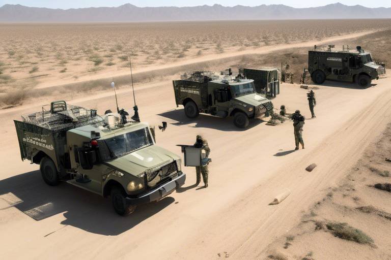
Coordination with Ground Forces
When it comes to tackling the complex web of drug trafficking, is absolutely crucial. Imagine a chess game where every piece must work in harmony to achieve victory; that's how law enforcement agencies function in counter-narcotics operations. The synergy between aerial surveillance provided by satellites and the boots on the ground is what transforms intelligence into action. This collaboration not only enhances operational efficiency but also maximizes the chances of successfully intercepting drug shipments before they reach their intended destinations.
One of the primary advantages of using satellite data is the ability to provide real-time information that aids ground forces in making informed decisions. For instance, when a satellite detects unusual activity—such as a sudden congregation of vehicles in a remote area—this information can be quickly relayed to ground units. These units can then be directed to investigate, often leading to the discovery of hidden drug caches or the apprehension of traffickers. The speed and accuracy of this coordination can mean the difference between success and failure in an operation.
Furthermore, the integration of Global Positioning Systems (GPS) technology allows for seamless communication between aerial and ground units. Ground forces can receive precise coordinates from satellites, enabling them to navigate to specific locations efficiently. This is particularly important in challenging terrains where traditional navigation methods may fall short. The ability to track movements in real-time not only helps in intercepting drug shipments but also aids in dismantling trafficking networks by pinpointing key players involved in the operations.
To illustrate the importance of this coordination, consider a hypothetical scenario: a satellite identifies a suspicious vessel off the coast known for smuggling drugs. The satellite relays this information to a command center, which immediately dispatches ground forces equipped with GPS technology. As these forces approach the vessel, they can adjust their route based on the satellite's updates, ensuring they arrive at the right place at the right time. Such precise coordination can lead to the successful seizure of illicit cargo and the arrest of traffickers, disrupting their operations significantly.
In summary, effective coordination with ground forces is not just an operational necessity; it's a tactical advantage. By leveraging satellite technology, law enforcement agencies can enhance their capabilities, making them more agile and responsive to the ever-evolving tactics of drug traffickers. The combination of aerial surveillance and ground action creates a powerful force in the fight against drug trafficking, illustrating how technology and teamwork can come together to achieve remarkable outcomes.
- How do satellites help in counter-narcotics operations?
Satellites provide essential surveillance data, enabling law enforcement to monitor drug trafficking routes and activities effectively. - What role does GPS play in drug interdiction efforts?
GPS technology allows for precise tracking of vehicles and coordination between aerial and ground forces, enhancing operational efficiency. - What challenges do satellite operations face?
Challenges include weather impacts on imaging quality, technological limitations, and the need for skilled personnel to analyze data effectively. - How does data analytics improve counter-narcotics strategies?
Advanced data analytics can reveal patterns in drug trafficking, helping agencies allocate resources and predict potential hotspots for trafficking.
Remote Sensing Capabilities
Remote sensing technology has become a game-changer in the fight against drug trafficking, providing law enforcement agencies with the ability to monitor vast areas that are otherwise difficult to access. Imagine being able to detect illegal drug cultivation from miles above the ground, like an eagle soaring high, spotting its prey. This capability not only aids in identifying potential drug production sites but also assists in monitoring the environmental impact of such activities.
One of the most significant advantages of remote sensing is its ability to collect data over large geographical areas quickly and efficiently. Utilizing satellite imagery, authorities can pinpoint regions where illegal crops, such as coca or marijuana, are being cultivated. This information is vital for planning eradication efforts and deploying resources effectively. For instance, by analyzing changes in land use and vegetation patterns, agencies can determine where illicit activities are expanding.
Moreover, remote sensing can be complemented with other technologies to enhance its effectiveness. For example, when combined with geographic information systems (GIS), satellite data can be layered with various datasets, such as demographic information and historical trafficking routes. This integration allows for a more comprehensive understanding of the dynamics at play in drug trafficking, enabling authorities to make informed decisions.
However, the use of remote sensing is not without its challenges. The quality of satellite images can be impacted by factors such as cloud cover or atmospheric conditions, which can obscure critical information. Therefore, it's essential for agencies to utilize a combination of different imaging techniques, including optical, radar, and infrared, to ensure a more reliable analysis. In addition, the interpretation of satellite data requires skilled personnel who can analyze the imagery effectively and translate it into actionable intelligence.
In summary, remote sensing capabilities provide a vital tool in the counter-narcotics arsenal. By harnessing the power of satellite technology, law enforcement can enhance their surveillance efforts, leading to more successful interventions against drug trafficking. As technology continues to evolve, the potential for remote sensing to revolutionize the fight against drugs will only grow stronger.
- What is remote sensing? Remote sensing refers to the collection of data about an object or area from a distance, typically using satellites or aircraft.
- How does remote sensing help in counter-narcotics operations? It allows authorities to monitor large areas for illegal drug cultivation and trafficking activities, providing crucial data for enforcement actions.
- What are the limitations of remote sensing? Limitations include weather conditions affecting image quality and the need for skilled analysts to interpret the data accurately.
- Can remote sensing be used in conjunction with other technologies? Yes, combining remote sensing with GIS and other data sources enhances the analysis and effectiveness of counter-narcotics strategies.
Data Analytics in Counter-Narcotics
In the ever-evolving battle against drug trafficking, data analytics has emerged as a game-changer. By harnessing the power of satellite imagery and advanced analytical techniques, law enforcement agencies can gain unprecedented insights into drug trafficking patterns. This is akin to having a magnifying glass that reveals hidden details in a complex puzzle. Imagine being able to sift through mountains of data to uncover what was once obscured—this is the magic of data analytics in counter-narcotics operations.
One of the primary advantages of employing data analytics is its ability to reveal patterns and trends in drug trafficking activities. By analyzing historical data, agencies can identify hotspots where drug-related activities are most prevalent. This allows for a more strategic allocation of resources, ensuring that law enforcement is deployed where it’s needed most. For example, if data shows a spike in trafficking activities in a particular region, authorities can focus their efforts there, rather than spreading themselves thin across multiple areas.
Moreover, the integration of predictive modeling techniques takes this a step further. Predictive modeling uses algorithms to forecast potential trafficking hotspots based on various factors, including geographical, socio-economic, and historical data. Think of it as a weather forecast for drug trafficking—just as meteorologists predict storms, law enforcement can anticipate where drug trafficking might occur next. This proactive approach allows agencies to preemptively deploy resources, which is crucial in stopping drug shipments before they reach their destination.
Collaboration is another key aspect of data analytics in counter-narcotics. When countries and international organizations come together to share data, the fight against drug trafficking becomes a coordinated effort rather than isolated skirmishes. For instance, if one country detects unusual activity in its satellite data, sharing that information with neighboring countries can lead to a comprehensive understanding of trafficking networks. This collaboration not only enhances the effectiveness of operations but also fosters a sense of unity in the global fight against drugs.
However, the power of data analytics is not without its challenges. The sheer volume of data generated can be overwhelming, and without the right tools and skilled personnel, valuable insights may be lost. Agencies must invest in training and technology to ensure that they can interpret and analyze satellite imagery effectively. Additionally, the integration of data from various sources—satellite images, ground reports, and historical data—requires sophisticated systems that can handle the complexity of this information.
In conclusion, the role of data analytics in counter-narcotics operations cannot be overstated. By leveraging satellite imagery to uncover patterns, predict future activities, and foster international collaboration, law enforcement agencies are better equipped to combat drug trafficking. The journey may be fraught with challenges, but with the right tools and strategies, the fight against drugs can become more effective, ultimately leading to safer communities worldwide.
- What is the role of satellite imagery in counter-narcotics?
Satellite imagery provides crucial data that helps law enforcement monitor drug trafficking routes and identify illegal cultivation areas. - How does data analytics improve counter-narcotics operations?
Data analytics helps agencies identify patterns, predict hotspots, and allocate resources more effectively, enhancing overall operational efficiency. - What are the challenges faced in data analytics for counter-narcotics?
Challenges include data interpretation, the need for skilled personnel, and the integration of various data sources.
Predictive Modeling
Predictive modeling is like having a crystal ball that allows law enforcement agencies to foresee potential drug trafficking activities before they even occur. By leveraging advanced algorithms and historical data, authorities can identify patterns that indicate where and when drug trafficking is likely to happen. This proactive approach is essential in the ever-evolving landscape of narcotics operations, where traffickers continuously adapt their strategies to evade capture.
Imagine if you could predict the weather not just for today, but for the entire week ahead. Similarly, predictive modeling analyzes vast amounts of satellite data to forecast trafficking hotspots. For instance, by examining past data on drug seizures, law enforcement can pinpoint regions that have historically been used for smuggling operations. This enables them to deploy resources strategically, ensuring that they are in the right place at the right time to intercept illegal activities.
The process begins with data collection, where various factors such as geographical terrain, historical trafficking routes, and even socio-economic indicators are considered. Once this data is gathered, it is fed into machine learning models that can identify correlations and trends. The output might look something like this:
| Region | Historical Seizures | Predicted Activity Level |
|---|---|---|
| Southwest Border | 150 | High |
| Eastern Seaboard | 80 | Medium |
| Midwest | 30 | Low |
This table illustrates how predictive modeling can effectively categorize regions based on their likelihood of drug trafficking activities. By focusing on high-risk areas, authorities can allocate their resources more efficiently, increasing the chances of successful operations.
Moreover, predictive modeling is not just about identifying current trends; it's also about anticipating future changes. For instance, if a new drug trafficking route emerges due to changes in law enforcement tactics or market demands, predictive models can adapt quickly, allowing authorities to stay one step ahead of traffickers. This adaptability is crucial in a world where drug trafficking networks are becoming increasingly sophisticated.
In conclusion, predictive modeling serves as a powerful tool in the arsenal of counter-narcotics operations. By utilizing data-driven insights, law enforcement can enhance their operational efficiency, ultimately leading to more successful interventions against drug trafficking. The future of counter-narcotics efforts looks promising, thanks to the integration of advanced technologies like predictive modeling.
- What is predictive modeling?
Predictive modeling is a statistical technique that uses historical data to forecast future events, such as drug trafficking activities.
- How does satellite technology aid in predictive modeling?
Satellite technology provides essential data on geographical patterns and historical trafficking routes, which are crucial for building predictive models.
- Can predictive modeling be used in other fields?
Yes, predictive modeling is widely used in various fields, including finance, healthcare, and marketing, to anticipate future trends and behaviors.
Collaboration with International Agencies
In the fight against drug trafficking, is not just beneficial; it's essential. The global nature of drug trade demands a united front, where countries share intelligence, resources, and strategies to combat this pervasive issue. Imagine trying to solve a complex puzzle with pieces scattered across the globe—this is what counter-narcotics agencies face every day. By working together, they can assemble a clearer picture of trafficking networks and disrupt their operations more effectively.
One of the most significant advantages of international collaboration is the ability to share real-time data. For instance, when one country detects unusual activity, it can quickly alert its partners, enabling a coordinated response. This kind of synergy not only enhances the efficiency of operations but also increases the chances of apprehending traffickers before they can move their illicit goods. Moreover, international agencies often provide training and resources to enhance local capabilities, ensuring that all parties are equipped to tackle the evolving tactics of drug traffickers.
Furthermore, collaborative efforts can lead to the establishment of joint task forces that pool resources from multiple nations. These task forces can operate across borders, making it easier to track and intercept drug shipments. For example, the collaboration between the United States and several Latin American countries has led to significant seizures of narcotics and the dismantling of major trafficking organizations. Such partnerships exemplify how shared goals can lead to remarkable achievements in the fight against drugs.
However, this collaboration is not without its challenges. Different countries may have varying legal frameworks, operational protocols, and levels of technological advancement. To overcome these hurdles, international agencies must engage in ongoing dialogue and establish common standards for data sharing and operational procedures. This ensures that all parties are on the same page and can act swiftly and decisively when necessary.
In conclusion, the fight against drug trafficking is a global endeavor that requires a collective approach. By fostering collaboration among international agencies, countries can leverage their strengths and resources to create a more formidable defense against the drug trade. As they continue to work together, the potential for success increases, paving the way for safer communities worldwide.
- Why is international collaboration important in counter-narcotics efforts?
International collaboration allows countries to share intelligence, resources, and strategies, making it easier to combat the global nature of drug trafficking. - What are some examples of successful international collaborations?
Collaborations such as the joint task forces between the United States and Latin American countries have led to significant drug seizures and dismantling of trafficking networks. - What challenges do countries face when collaborating?
Differences in legal frameworks, operational protocols, and levels of technological advancement can create obstacles to effective collaboration.
Challenges in Satellite Operations
While satellites have revolutionized counter-narcotics operations, they are not without their challenges. One of the primary hurdles is the interpretation of data. The vast amounts of data generated by satellite imagery can be overwhelming. Analyzing this data requires specialized skills, and without trained personnel, crucial insights may be missed. Imagine trying to find a needle in a haystack; that's what it can feel like when sifting through layers of satellite images without the right tools or expertise.
Another significant challenge is the impact of weather and environmental factors. Satellites rely on clear skies to capture high-quality images, but adverse weather conditions like clouds, rain, or fog can severely limit visibility. For instance, when a storm rolls in, the ability to monitor drug trafficking routes diminishes, leaving law enforcement agencies in the dark. This unpredictability can hinder timely interventions, allowing traffickers to exploit the situation to their advantage.
Moreover, there are inherent technological limitations in satellite operations. Not all areas are easily monitored due to geographical barriers or restrictions in satellite coverage. Some remote regions may be beyond the reach of current satellite technology, making it difficult to gather intelligence on drug trafficking activities in those locales. In such cases, authorities might need to rely on alternative methods, such as ground surveillance or human intelligence, which can be less reliable and more resource-intensive.
To illustrate these challenges, consider the following table that outlines some of the key issues faced in satellite operations for counter-narcotics:
| Challenge | Description |
|---|---|
| Data Interpretation | Requires specialized skills; overwhelming volume of data can lead to missed insights. |
| Weather Conditions | Clouds, rain, and fog can limit satellite imaging quality, hindering monitoring efforts. |
| Technological Limitations | Some regions are out of satellite coverage, necessitating alternative methods for intelligence gathering. |
In summary, while satellites are invaluable tools in the fight against drug trafficking, the challenges they face cannot be overlooked. Addressing these issues requires continuous advancements in technology, training for personnel, and innovative strategies to ensure that the fight against narcotics remains effective and efficient.
- What are the main challenges faced by satellites in counter-narcotics operations? The main challenges include data interpretation, weather conditions, and technological limitations.
- How does weather affect satellite operations? Adverse weather can obscure visibility, making it difficult for satellites to capture clear images necessary for monitoring drug trafficking.
- What skills are needed to interpret satellite data effectively? Specialized training in data analysis, remote sensing, and geographic information systems (GIS) is essential for personnel working with satellite imagery.
Weather and Environmental Factors
When it comes to the effectiveness of satellite operations in counter-narcotics efforts, can play a significant role. Imagine trying to capture a beautiful sunset on camera, only to have clouds roll in and obscure the view. Similarly, satellites rely on clear skies to gather accurate data. Adverse weather conditions, such as heavy rain, fog, or snow, can severely limit the quality of satellite imagery. This can lead to missed opportunities in detecting illegal drug activities, making it crucial for law enforcement agencies to consider these factors in their operations.
Moreover, environmental conditions such as seasonal changes and geographical features can also impact satellite performance. For instance, during certain times of the year, vegetation may grow thick, camouflaging illicit drug cultivation sites from satellite detection. In contrast, bare landscapes during winter months might reveal hidden areas of illegal activity that were previously obscured. As a result, authorities must remain vigilant and adaptable, employing a combination of satellite technology and ground intelligence to overcome these challenges.
To further illustrate the impact of weather on satellite operations, consider the following table that outlines various weather conditions and their effects on satellite imaging:
| Weather Condition | Effect on Satellite Imaging |
|---|---|
| Clear Skies | Optimal imaging conditions; high-resolution data. |
| Cloud Cover | Obscures ground features; reduces image clarity. |
| Heavy Rain | Can lead to signal interference; poor image quality. |
| Fog | Limits visibility; challenges in detecting ground activities. |
| Snow | Can reveal hidden areas; but may also obscure features. |
In addition to these challenges, the geographical terrain itself can pose issues for satellite operations. Dense forests, mountainous regions, and urban environments can all obstruct signals, leading to gaps in data collection. This makes it essential for agencies to combine satellite intelligence with other forms of surveillance, such as aerial reconnaissance or ground patrols, to ensure a comprehensive understanding of drug trafficking activities.
Ultimately, while satellites provide invaluable support in counter-narcotics operations, the influence of weather and environmental factors cannot be overlooked. As technology continues to advance, the hope is that new innovations will mitigate these challenges, allowing for more effective monitoring and enforcement against drug trafficking worldwide.
- What types of satellites are used in counter-narcotics operations?
Various types of satellites, including optical, radar, and infrared satellites, are utilized to gather intelligence on drug trafficking activities.
- How does weather affect satellite imaging?
Weather conditions such as clouds, rain, and fog can obscure images and reduce the quality of data collected by satellites.
- Can satellites detect illegal drug cultivation?
Yes, satellites can identify patterns and anomalies in land use, which may indicate illegal drug cultivation.
- What role does GPS play in counter-narcotics efforts?
GPS technology helps track vehicle movements and coordinates operations between aerial and ground forces, enhancing the effectiveness of interventions.
Technological Limitations
While satellite technology has revolutionized the way we approach counter-narcotics operations, it is not without its limitations. One of the primary challenges lies in the quality of data that satellites can provide. Factors such as atmospheric conditions, including clouds, rain, and fog, can significantly impact the clarity of satellite imagery. For instance, a cloudy sky can obscure visibility, making it difficult for law enforcement agencies to gather accurate intelligence on drug trafficking activities. This unpredictability can lead to gaps in surveillance, leaving authorities vulnerable to missing critical movements of illicit shipments.
Moreover, the resolution of satellite images can also be a limiting factor. While advancements have led to higher resolution images, there are still areas where the detail is insufficient to identify specific activities or assess the scale of operations, particularly in dense urban environments or remote rural areas. In these situations, the imagery may provide a broad overview, but it lacks the granularity needed for precise interventions. For instance, distinguishing between legal agricultural practices and illegal drug cultivation can be challenging without higher resolution data.
Another significant limitation is the technological infrastructure required to process and analyze the data collected. Not all countries have the necessary resources or personnel to effectively interpret satellite imagery. This gap can lead to delays in decision-making and response times, which are crucial in counter-narcotics operations. The demand for skilled analysts who can translate raw data into actionable intelligence is high, yet there is often a shortage of trained professionals in this field. Consequently, agencies may struggle to keep pace with the fast-evolving tactics of drug traffickers.
Additionally, the cost of satellite technology can be prohibitive for many regions, especially in developing countries where drug trafficking is rampant. Investing in satellite systems and the associated infrastructure may not be feasible, forcing these countries to rely on less effective methods for intelligence gathering. This disparity creates a significant challenge, as drug traffickers often exploit these weaknesses to operate with relative impunity.
In summary, while satellite technology offers unparalleled advantages in the fight against drug trafficking, it is essential to recognize its limitations. Addressing these challenges requires a multifaceted approach, including investments in technology, training personnel, and fostering international collaboration. Only then can we hope to fully leverage the potential of satellites in counter-narcotics operations.
- What are the main advantages of using satellites in counter-narcotics operations? Satellites provide enhanced surveillance capabilities, real-time data transmission, and improved coordination among law enforcement agencies.
- How do weather conditions affect satellite operations? Adverse weather can obscure satellite imagery, leading to gaps in data and potentially missing critical drug trafficking activities.
- What role does GPS play in counter-narcotics? GPS technology helps track vehicle movements, allowing authorities to intercept drug shipments and analyze smuggling routes.
- Are there any international collaborations in counter-narcotics efforts? Yes, many countries and international organizations work together to share data and strategies to combat global drug trafficking networks.
Frequently Asked Questions
- How do satellites enhance counter-narcotics operations?
Satellites play a crucial role in counter-narcotics operations by providing advanced surveillance techniques, real-time data transmission, and remote sensing capabilities. They help law enforcement agencies monitor drug trafficking routes, gather intelligence, and coordinate responses effectively.
- What types of satellite surveillance techniques are used?
There are several satellite surveillance techniques, including optical imaging, radar, and infrared imaging. These technologies allow authorities to effectively monitor areas suspected of drug trafficking and cultivation, enabling them to take timely action against illegal activities.
- How does real-time data transmission improve operations?
Real-time data transmission enables immediate communication and coordination between agencies involved in counter-narcotics efforts. This immediacy allows for quicker responses to detected activities, which significantly boosts the operational efficiency of law enforcement efforts.
- What role does GPS technology play in drug trafficking interventions?
GPS technology is essential for tracking the movements of vehicles involved in drug trafficking. By pinpointing locations and routes, authorities can intercept shipments and disrupt trafficking networks more effectively.
- Can satellites help identify illegal drug cultivation areas?
Absolutely! Remote sensing capabilities of satellites are instrumental in detecting illegal drug cultivation. By analyzing satellite images, authorities can identify potential cultivation sites and focus eradication efforts where they are most needed.
- What are the challenges faced in satellite operations?
Despite their advantages, satellite operations encounter challenges such as data interpretation difficulties, technological limitations, and environmental factors like weather conditions that can affect imaging quality. Skilled personnel are also needed to analyze the data effectively.
- How do weather conditions impact satellite imaging?
Weather conditions such as clouds, rain, and fog can significantly degrade the quality of satellite images. This can lead to challenges in gathering accurate data necessary for monitoring drug trafficking activities.
- What is predictive modeling in the context of counter-narcotics?
Predictive modeling involves using data analytics to forecast potential drug trafficking hotspots. By identifying patterns and trends, law enforcement can proactively allocate resources and deploy operations in areas that are likely to see increased trafficking activity.
- How does international collaboration enhance counter-narcotics efforts?
Collaboration between countries and international organizations facilitates data sharing and resource allocation. This comprehensive approach allows for a more effective strategy against global drug trafficking networks, improving overall success rates in combating this issue.